
Geographic Region: HONDURAS
Feature: ISLA DE ROATAN
|
Geographic Region: HONDURAS Feature: ISLA DE ROATAN |
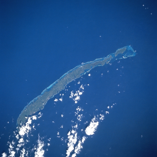 |
| STS51A-45-0027 Roatan Island, Honduras November 1984 The largest of the Bay Islands, the hilly, reef-fringed island of Roatan can be seen in this north-northeast-looking view. Roatan island is 40 miles (64 km) long and less than 4 miles (6 km) wide. Roatan and the rest of the Bay Islands rests on the Bonacca Ridge about 40 miles (64 km) off the northern coast of Honduras. The ridge was formed as a result of an enormous crack along the Caribbean Sea floor. Lava from the earth's mantle welled up through the crack, forming the Caribbean Plate, which buckled and created Bonacca Ridge and the Bay Islands, including Roatan. Until the fall of 1998, Roatan was a vacation resort area known for its great diving and trophy fishing. In the fall of 1998, Hurricane Mitch, a category five hurricane with winds gusting to over 150 miles per hour (243 km per hour), struck the island. The storm stalled over the island before finally moving on to the northern Honduran mainland. The island was devastated by extremely high winds and high waves. Repairs to the devastated island are presently ongoing, and tourists are returning. |
| Images: | All Available Images Low-Resolution 290k |
|
| Mission: | STS51A |
|
| Roll - Frame: | 45 - 27 |
|
| Geographical Name: | HONDURAS |
|
| Features: | ISLA DE ROATAN |
|
| Center Lat x Lon: | 16.5N x 86.5W |
|
| Film Exposure: | N | N=Normal exposure, U=Under exposed, O=Over exposed, F=out of Focus |
| Percentage of Cloud Cover-CLDP: | 10 |
|
| Camera:: | HB |
|
| Camera Tilt: | LO | LO=Low Oblique, HO=High Oblique, NV=Near Vertical |
| Camera Focal Length: | 250 |
|
| Nadir to Photo Center Direction: | The direction from the nadir to the center point, N=North, S=South, E=East, W=West |
|
| Stereo?: | N | Y=Yes there is an adjacent picture of the same area, N=No there isn't |
| Orbit Number: | 4 |
|
| Date: | 198411__ | YYYYMMDD |
| Time: | GMT HHMMSS |
|
| Nadir Lat: | N |
Latitude of suborbital point of spacecraft |
| Nadir Lon: | E |
Longitude of suborbital point of spacecraft |
| Sun Azimuth: | Clockwise angle in degrees from north to the sun measured at the nadir point |
|
| Space Craft Altitude: | nautical miles |
|
| Sun Elevation: | Angle in degrees between the horizon and the sun, measured at the nadir point |
|
| Land Views: | ISLAND, HILL |
|
| Water Views: | SEA, REEF |
|
| Atmosphere Views: | |
|
| Man Made Views: | |
|
| City Views: | |
|
Photo is not associated with any sequences | ||
| NASA Home Page |
JSC Home Page |
JSC Digital Image Collection |
Earth Science & Remote Sensing |
|
This service is provided by the International Space Station program and the JSC Earth Science & Remote Sensing Unit, ARES Division, Exploration Integration Science Directorate.

|