
Geographic Region: NICARAGUA
Feature: MASAYA VOLCANO PLUME
|
Geographic Region: NICARAGUA Feature: MASAYA VOLCANO PLUME |
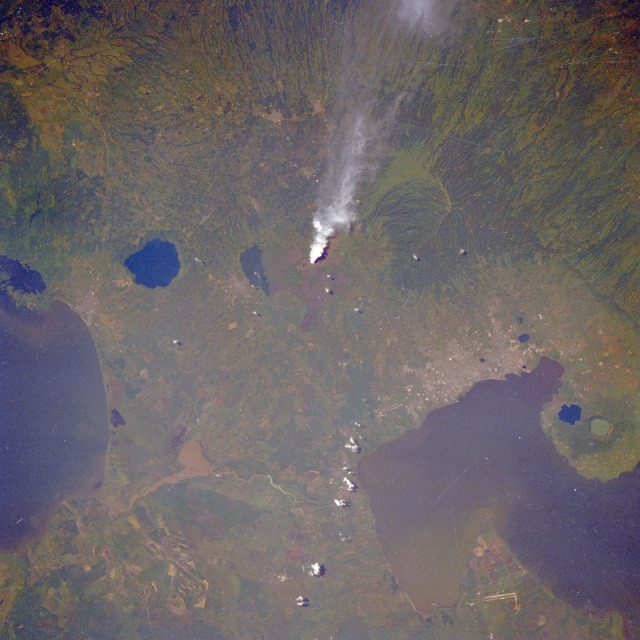 |
| STS-51A-032-0064 Managua, Nicaragua November 1984 Managua, with an estimated population of over 1 million, is the capital of Nicaragua and is located on the Central American volcanic axis. Five large, water-filled calderas show the northwest-southeast alignment of this single range of volcanoes through the region. The single smoke plume seems to emanate from an unnamed fissure vent west of the water-filled Nindire Caldera and Masaya Caldera (the larger, roughly circular feature east of the smoke). A radial drainage pattern west of the smoke indicates forested slopes on the flanks of a much older volcano. Two water-filled calderas appear on the peninsula northwest of Managua. The two large bodies of water--part of Lake Managua (north of Managua) and the northwestern part of Lake Nicaragua (east edge of the photograph)--are two freshwater lakes connected by a short river that flows from Lake Managua into Lake Nicaragua, ultimately emptying into the Caribbean Sea. Visible are airport runways (north margin of the photograph) and agricultural fields, many of which have circular irrigation patterns, in the fertile garden valley (northeast corner of photograph). |
| Images: | All Available Images Low-Resolution 115k |
|
| Mission: | STS51A |
|
| Roll - Frame: | 32 - 64 |
|
| Geographical Name: | NICARAGUA |
|
| Features: | MASAYA VOLCANO PLUME |
|
| Center Lat x Lon: | 12.0N x 86W |
|
| Film Exposure: | N | N=Normal exposure, U=Under exposed, O=Over exposed, F=out of Focus |
| Percentage of Cloud Cover-CLDP: | 0 |
|
| Camera:: | HB |
|
| Camera Tilt: | 16 | LO=Low Oblique, HO=High Oblique, NV=Near Vertical |
| Camera Focal Length: | 250 |
|
| Nadir to Photo Center Direction: | NE | The direction from the nadir to the center point, N=North, S=South, E=East, W=West |
| Stereo?: | Y | Y=Yes there is an adjacent picture of the same area, N=No there isn't |
| Orbit Number: | 20 |
|
| Date: | 19841109 | YYYYMMDD |
| Time: | 171247 | GMT HHMMSS |
| Nadir Lat: | 11.4N |
Latitude of suborbital point of spacecraft |
| Nadir Lon: | 86.5W |
Longitude of suborbital point of spacecraft |
| Sun Azimuth: | 171 | Clockwise angle in degrees from north to the sun measured at the nadir point |
| Space Craft Altitude: | 163 | nautical miles |
| Sun Elevation: | 61 | Angle in degrees between the horizon and the sun, measured at the nadir point |
| Land Views: | VOLCANO, PLAIN, CRATER |
|
| Water Views: | LAKE, SEDIMENT |
|
| Atmosphere Views: | |
|
| Man Made Views: | URBAN AREA, AIRPORT |
|
| City Views: | MANAGUA |
|
Photo is not associated with any sequences | ||
| NASA Home Page |
JSC Home Page |
JSC Digital Image Collection |
Earth Science & Remote Sensing |
|
This service is provided by the International Space Station program and the JSC Earth Science & Remote Sensing Unit, ARES Division, Exploration Integration Science Directorate.

|