
Geographic Region: USA-SOUTH DAKOTA
Feature: BLACK HILLS/RAPID CITY
|
Geographic Region: USA-SOUTH DAKOTA Feature: BLACK HILLS/RAPID CITY |
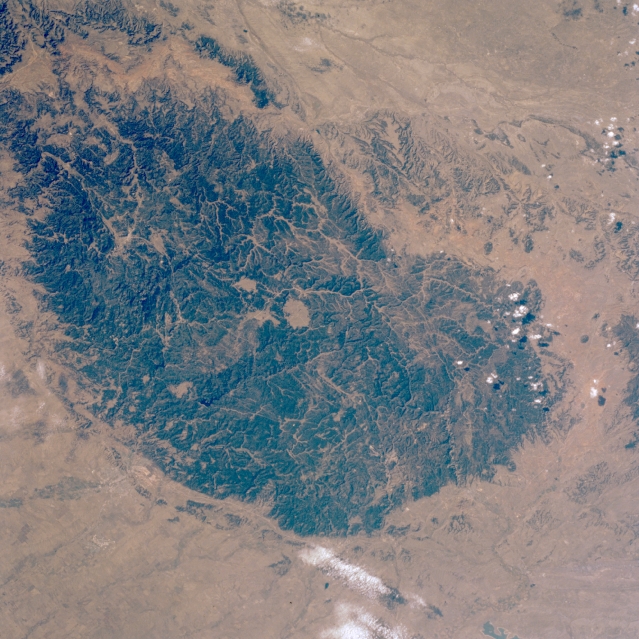 |
| STS41G-045-0046 Black Hills, South Dakota, U.S.A. October 1984 The Black Hills, situated between the Belle Fourche and Cheyenne Rivers, are featured in this low-oblique, south-southwest-looking photograph. The Black Hills cover approximately 6000 square miles (15 500 square kilometers), rising abruptly 3000 feet (900 meters) above the surrounding plains. A major recreational area, the hills are the site of Mount Rushmore and the new Chief Crazy Horse Monument, which is being carved. This small group of mountains on the South Dakota-Wyoming border lies just south of the geographic center of the United States. Geologically the Black Hills are an elliptical dome dissected by streams, comprising high ridges, deep valleys, and a plateau. The Black Hills received their name because of the dark pine-covered slopes of the Black Hills National Forest, which appears black from a distance. Gold was discovered in the hills in 1874 during an expedition led by General George Custer; the resulting gold rush drove out the Lakota Sioux Indians. Gold is still mined in the area; Homestake Mine is the largest producing gold mine in the United States. In the eastern foothills lies Rapid City (barely discernible), the major commercial, trade, and transportation center for the region. |
| Images: | All Available Images Low-Resolution 373k |
|
| Mission: | STS41G |
|
| Roll - Frame: | 45 - 46 |
|
| Geographical Name: | USA-SOUTH DAKOTA |
|
| Features: | BLACK HILLS/RAPID CITY |
|
| Center Lat x Lon: | 44.0N x 103.5W |
|
| Film Exposure: | N | N=Normal exposure, U=Under exposed, O=Over exposed, F=out of Focus |
| Percentage of Cloud Cover-CLDP: | 2 |
|
| Camera:: | HB |
|
| Camera Tilt: | 4 | LO=Low Oblique, HO=High Oblique, NV=Near Vertical |
| Camera Focal Length: | 100 |
|
| Nadir to Photo Center Direction: | NE | The direction from the nadir to the center point, N=North, S=South, E=East, W=West |
| Stereo?: | Y | Y=Yes there is an adjacent picture of the same area, N=No there isn't |
| Orbit Number: | 118 |
|
| Date: | 19841012 | YYYYMMDD |
| Time: | 175715 | GMT HHMMSS |
| Nadir Lat: | 43.9N |
Latitude of suborbital point of spacecraft |
| Nadir Lon: | 103.6W |
Longitude of suborbital point of spacecraft |
| Sun Azimuth: | 131 | Clockwise angle in degrees from north to the sun measured at the nadir point |
| Space Craft Altitude: | 124 | nautical miles |
| Sun Elevation: | 37 | Angle in degrees between the horizon and the sun, measured at the nadir point |
| Land Views: | HILL, FOREST, PLAIN, FAULT |
|
| Water Views: | |
|
| Atmosphere Views: | |
|
| Man Made Views: | |
|
| City Views: | |
|
Photo is not associated with any sequences | ||
| NASA Home Page |
JSC Home Page |
JSC Digital Image Collection |
Earth Science & Remote Sensing |
|
This service is provided by the International Space Station program and the JSC Earth Science & Remote Sensing Unit, ARES Division, Exploration Integration Science Directorate.

|