
Geographic Region: USA-CALIFORNIA
Feature: MONO LAKE/SIERRA NEVADAS
|
Geographic Region: USA-CALIFORNIA Feature: MONO LAKE/SIERRA NEVADAS |
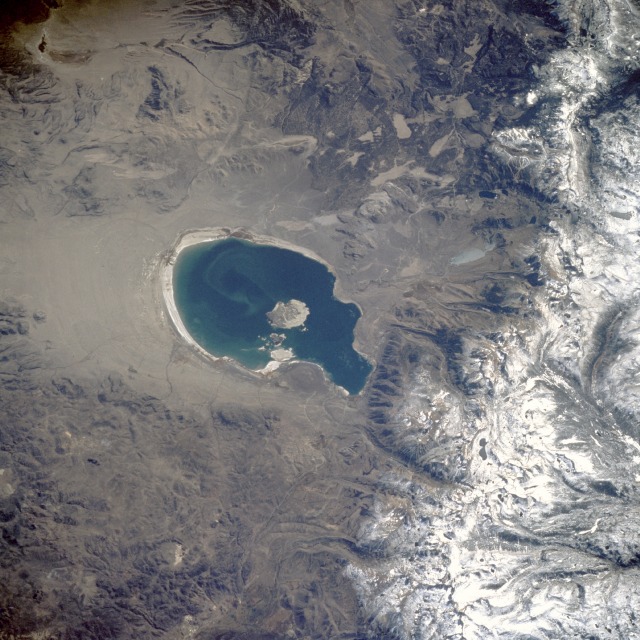 |
| STS41G-044-0019 Mono Lake, California, U.S.A. October 1985 Located on the eastern side of the high, snow-covered Sierra Nevada, Mono Lake can be seen in the center of this north-northwest-looking, low-oblique photograph. The lake, 14 miles (23 kilometers) long and 9 miles (14 kilometers) wide, is unique in that it is fed by numerous springs that rise to the surface through beds of saline sands. Though the lake is saline, it teems with life. Microscopic algae thrive on the mineral salts and are, in turn, preyed upon by millions of brine shrimp, a species of shrimp found nowhere else in the world. Millions of brine flies feed on other algae found in the lake. This aggregation of food attracts more than 1 million birds to the lake each year. This entire ecosystem, however, is in danger of extinction because water is being drawn from the lake in great volumes to supply the thirsty population of metropolitan Los Angeles. When this photograph was taken in 1985, the lake's water volume had already decreased, as evidenced by the exposed shoreline surrounding the lake. Water levels have continued to decline since 1985, and the salinity of the lake has doubled--disturbing trends that State and Federal Government agencies are attempting to halt. |
| Images: | All Available Images Low-Resolution 145k |
|
| Mission: | STS41G |
|
| Roll - Frame: | 44 - 19 |
|
| Geographical Name: | USA-CALIFORNIA |
|
| Features: | MONO LAKE/SIERRA NEVADAS |
|
| Center Lat x Lon: | 38.0N x 119W |
|
| Film Exposure: | N | N=Normal exposure, U=Under exposed, O=Over exposed, F=out of Focus |
| Percentage of Cloud Cover-CLDP: | 0 |
|
| Camera:: | HB |
|
| Camera Tilt: | 34 | LO=Low Oblique, HO=High Oblique, NV=Near Vertical |
| Camera Focal Length: | 250 |
|
| Nadir to Photo Center Direction: | SE | The direction from the nadir to the center point, N=North, S=South, E=East, W=West |
| Stereo?: | N | Y=Yes there is an adjacent picture of the same area, N=No there isn't |
| Orbit Number: | 119 |
|
| Date: | 19841012 | YYYYMMDD |
| Time: | 192813 | GMT HHMMSS |
| Nadir Lat: | 39.1N |
Latitude of suborbital point of spacecraft |
| Nadir Lon: | 119.8W |
Longitude of suborbital point of spacecraft |
| Sun Azimuth: | 135 | Clockwise angle in degrees from north to the sun measured at the nadir point |
| Space Craft Altitude: | 123 | nautical miles |
| Sun Elevation: | 43 | Angle in degrees between the horizon and the sun, measured at the nadir point |
| Land Views: | MOUNTAIN, BASIN, FAULT |
|
| Water Views: | LAKE |
|
| Atmosphere Views: | |
|
| Man Made Views: | |
|
| City Views: | |
|
Photo is not associated with any sequences | ||
| NASA Home Page |
JSC Home Page |
JSC Digital Image Collection |
Earth Science & Remote Sensing |
|
This service is provided by the International Space Station program and the JSC Earth Science & Remote Sensing Unit, ARES Division, Exploration Integration Science Directorate.

|