
Geographic Region: USA-IDAHO
Feature: CRATERS OF MOON NATL MON
|
Geographic Region: USA-IDAHO Feature: CRATERS OF MOON NATL MON |
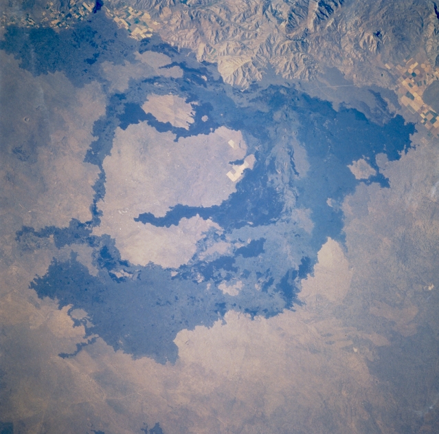 |
| STS41G-036-0095 Craters of the Moon National Monument, Idaho, U.S.A. October 1984 Craters of the Moon National Monument and surrounding lava flows, located along the northern border of the Snake River Plain, are featured in this spectacular north-looking, low-oblique view. This showcase of volcanic formations, including lava flows, cinder cones, and craters, was created by a fissure about 50 miles (80 kilometers) long in the Earth's crust. Through this zone of weakness, known as the Great Rift, lava frequently welled up to the surface over thousands of years. With each successive series of eruptions, older volcanic formations were buried, and new ones were superimposed on their surfaces. The barren black lava flows were emitted during the most recent eruptions, which occurred approximately 2000 years ago. |
| Images: | All Available Images Low-Resolution 324k |
|
| Mission: | STS41G |
|
| Roll - Frame: | 36 - 95 |
|
| Geographical Name: | USA-IDAHO |
|
| Features: | CRATERS OF MOON NATL MON |
|
| Center Lat x Lon: | 43.0N x 113.5W |
|
| Film Exposure: | N | N=Normal exposure, U=Under exposed, O=Over exposed, F=out of Focus |
| Percentage of Cloud Cover-CLDP: | 0 |
|
| Camera:: | HB |
|
| Camera Tilt: | 25 | LO=Low Oblique, HO=High Oblique, NV=Near Vertical |
| Camera Focal Length: | 250 |
|
| Nadir to Photo Center Direction: | N | The direction from the nadir to the center point, N=North, S=South, E=East, W=West |
| Stereo?: | N | Y=Yes there is an adjacent picture of the same area, N=No there isn't |
| Orbit Number: | 23 |
|
| Date: | 19841006 | YYYYMMDD |
| Time: | 210357 | GMT HHMMSS |
| Nadir Lat: | 41.9N |
Latitude of suborbital point of spacecraft |
| Nadir Lon: | 113.3W |
Longitude of suborbital point of spacecraft |
| Sun Azimuth: | 133 | Clockwise angle in degrees from north to the sun measured at the nadir point |
| Space Craft Altitude: | 143 | nautical miles |
| Sun Elevation: | 37 | Angle in degrees between the horizon and the sun, measured at the nadir point |
| Land Views: | VOLCANO, PLAIN, HILL |
|
| Water Views: | |
|
| Atmosphere Views: | |
|
| Man Made Views: | |
|
| City Views: | |
|
Photo is not associated with any sequences | ||
| NASA Home Page |
JSC Home Page |
JSC Digital Image Collection |
Earth Science & Remote Sensing |
|
This service is provided by the International Space Station program and the JSC Earth Science & Remote Sensing Unit, ARES Division, Exploration Integration Science Directorate.

|