
Geographic Region: USA-NEVADA
Feature: SOUTHERN NEVADA
|
Geographic Region: USA-NEVADA Feature: SOUTHERN NEVADA |
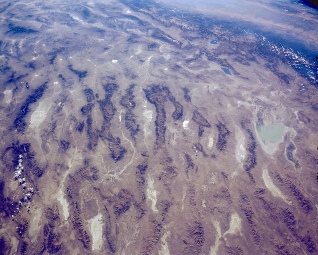 |
| STS41G-121-0184 Basin and Range Province, Nevada, U.S.A. October 1984 Part of the intermontane basin region of central Nevada, known as the basin and range area, is featured in this panoramic, southwest-looking photograph. Apparent are long, dark, roughly parallel mountains spanning the center of the photograph, extending from the Stillwater Range immediately east of Carson Sink (near the middle right edge of the photograph) to Grant Range (near the left edge of the photograph). Interior drainage is a dominant feature of this landscape. The white features visible in most of the valleys are dry lakes (playas), typical of which is Alkali Flats, a highly reflective, salt-encrusted dry lake, southwest of which are Walker Lake (Nevada) and Mono Lake (California). Parts of the Sierra Nevada Mountains and San Joaquin Valley in California are visible at the top right of the photograph. |
| Images: | All Available Images Low-Resolution 287k |
|
| Mission: | STS41G |
|
| Roll - Frame: | 121 - 184 |
|
| Geographical Name: | USA-NEVADA |
|
| Features: | SOUTHERN NEVADA |
|
| Center Lat x Lon: | 39.0N x 117W |
|
| Film Exposure: | N | N=Normal exposure, U=Under exposed, O=Over exposed, F=out of Focus |
| Percentage of Cloud Cover-CLDP: | 5 |
|
| Camera:: | LH |
|
| Camera Tilt: | LO | LO=Low Oblique, HO=High Oblique, NV=Near Vertical |
| Camera Focal Length: | 90 |
|
| Nadir to Photo Center Direction: | The direction from the nadir to the center point, N=North, S=South, E=East, W=West |
|
| Stereo?: | N | Y=Yes there is an adjacent picture of the same area, N=No there isn't |
| Orbit Number: | 55 |
|
| Date: | 198410__ | YYYYMMDD |
| Time: | GMT HHMMSS |
|
| Nadir Lat: | N |
Latitude of suborbital point of spacecraft |
| Nadir Lon: | E |
Longitude of suborbital point of spacecraft |
| Sun Azimuth: | Clockwise angle in degrees from north to the sun measured at the nadir point |
|
| Space Craft Altitude: | nautical miles |
|
| Sun Elevation: | Angle in degrees between the horizon and the sun, measured at the nadir point |
|
| Land Views: | MOUNTAIN, VALLEY |
|
| Water Views: | LAKE, PLAYA |
|
| Atmosphere Views: | |
|
| Man Made Views: | |
|
| City Views: | |
|
Photo is not associated with any sequences | ||
| NASA Home Page |
JSC Home Page |
JSC Digital Image Collection |
Earth Science & Remote Sensing |
|
This service is provided by the International Space Station program and the JSC Earth Science & Remote Sensing Unit, ARES Division, Exploration Integration Science Directorate.

|