
Geographic Region: AUSTRALIA-NT
Feature: MACDONNELL RANGES
|
Geographic Region: AUSTRALIA-NT Feature: MACDONNELL RANGES |
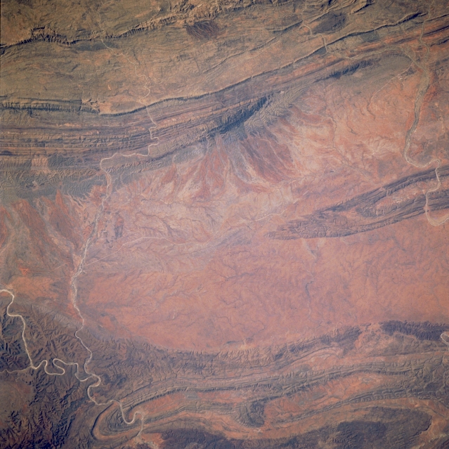 |
| STS41D-41-0031 MacDonnell Ranges, Northern Territory, Australia September 1984 The western (left) side of this image overlaps with a small geographic area on image STS41D-41-029, specifically the Finke River (bottom left). Ellery Creek, a small ephemeral stream and a tributaryof the Finke River, can also be traced across this desert terrain to its confluence with the Finke River at lower left. The plains between the MacDonnell Ranges (north) and the James/Krichauff Ranges (south) widen from west to east. The channel of Hugh Creek,another ephemeral stream, is visible in the upper right quadrant of the picture. Because of the lack of vegetation, folds in the bedrock strata can be traced over tens of kilometers. |
| Images: | All Available Images Low-Resolution 351k |
|
| Mission: | STS41D |
|
| Roll - Frame: | 41 - 31 |
|
| Geographical Name: | AUSTRALIA-NT |
|
| Features: | MACDONNELL RANGES |
|
| Center Lat x Lon: | 24S x 133.0E |
|
| Film Exposure: | N | N=Normal exposure, U=Under exposed, O=Over exposed, F=out of Focus |
| Percentage of Cloud Cover-CLDP: | 0 |
|
| Camera:: | HB |
|
| Camera Tilt: | 18 | LO=Low Oblique, HO=High Oblique, NV=Near Vertical |
| Camera Focal Length: | 250 |
|
| Nadir to Photo Center Direction: | SW | The direction from the nadir to the center point, N=North, S=South, E=East, W=West |
| Stereo?: | Y | Y=Yes there is an adjacent picture of the same area, N=No there isn't |
| Orbit Number: | 91 |
|
| Date: | 19840905 | YYYYMMDD |
| Time: | 045559 | GMT HHMMSS |
| Nadir Lat: | 23.6S |
Latitude of suborbital point of spacecraft |
| Nadir Lon: | 133.8E |
Longitude of suborbital point of spacecraft |
| Sun Azimuth: | 106 | Clockwise angle in degrees from north to the sun measured at the nadir point |
| Space Craft Altitude: | 161 | nautical miles |
| Sun Elevation: | 49 | Angle in degrees between the horizon and the sun, measured at the nadir point |
| Land Views: | MOUNTAIN, DESERT, PLAIN |
|
| Water Views: | RIVER |
|
| Atmosphere Views: | |
|
| Man Made Views: | |
|
| City Views: | |
|
Photo is not associated with any sequences | ||
| NASA Home Page |
JSC Home Page |
JSC Digital Image Collection |
Earth Science & Remote Sensing |
|
This service is provided by the International Space Station program and the JSC Earth Science & Remote Sensing Unit, ARES Division, Exploration Integration Science Directorate.

|