
Geographic Region: AUSTRALIA-NT
Feature: MACDONNELL RANGES
|
Geographic Region: AUSTRALIA-NT Feature: MACDONNELL RANGES |
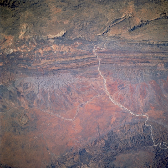 |
| STS41D-41-0029 MacDonnell Ranges, Northern Territory, Australia September 1984 The parallel, folded ridges stretching east-west across the upper half of the picture are part of the MacDonnell Ranges of arid central Australia (Northern Territory). Finke River, the curving light-colored dry channel cuts through the MacDonnell Ranges (north) and the James/Krichauff Ranges (south). A small tributary (ephemeral at best) can also be traced westward across the uplifted intermontane plain from its confluence with the Finke River (slightly right of center). The oval feature (lower left quadrant) is Gosses Bluff, an impact crater. The varied colors throughout the image reflect differing types of bedrock and iron content of the sediment. Refer to STS41D-41-031 for overlapping coverage east of this image. |
| Images: | All Available Images Low-Resolution 359k |
|
| Mission: | STS41D |
|
| Roll - Frame: | 41 - 29 |
|
| Geographical Name: | AUSTRALIA-NT |
|
| Features: | MACDONNELL RANGES |
|
| Center Lat x Lon: | 24S x 132.5E |
|
| Film Exposure: | N | N=Normal exposure, U=Under exposed, O=Over exposed, F=out of Focus |
| Percentage of Cloud Cover-CLDP: | 0 |
|
| Camera:: | HB |
|
| Camera Tilt: | 19 | LO=Low Oblique, HO=High Oblique, NV=Near Vertical |
| Camera Focal Length: | 250 |
|
| Nadir to Photo Center Direction: | SW | The direction from the nadir to the center point, N=North, S=South, E=East, W=West |
| Stereo?: | Y | Y=Yes there is an adjacent picture of the same area, N=No there isn't |
| Orbit Number: | 91 |
|
| Date: | 19840905 | YYYYMMDD |
| Time: | 045550 | GMT HHMMSS |
| Nadir Lat: | 23.4S |
Latitude of suborbital point of spacecraft |
| Nadir Lon: | 133.2E |
Longitude of suborbital point of spacecraft |
| Sun Azimuth: | 106 | Clockwise angle in degrees from north to the sun measured at the nadir point |
| Space Craft Altitude: | 161 | nautical miles |
| Sun Elevation: | 49 | Angle in degrees between the horizon and the sun, measured at the nadir point |
| Land Views: | CRATER, MOUNTAIN |
|
| Water Views: | RIVER |
|
| Atmosphere Views: | |
|
| Man Made Views: | |
|
| City Views: | |
|
Photo is not associated with any sequences | ||
| NASA Home Page |
JSC Home Page |
JSC Digital Image Collection |
Earth Science & Remote Sensing |
|
This service is provided by the International Space Station program and the JSC Earth Science & Remote Sensing Unit, ARES Division, Exploration Integration Science Directorate.

|