
Geographic Region: AUSTRALIA-NT
Feature: JOSEPH BONAPARTE GULF
|
Geographic Region: AUSTRALIA-NT Feature: JOSEPH BONAPARTE GULF |
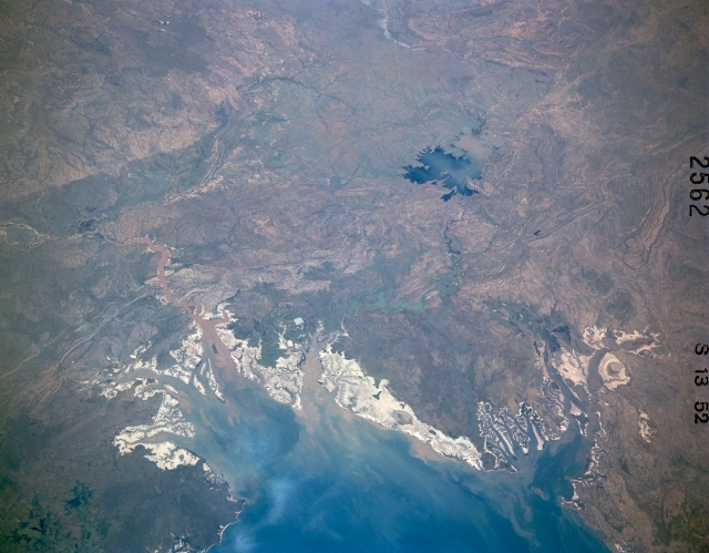 |
| STS41C-52-2562 Joseph Bonaparte Gulf, Northern Territory, Australia April 1984 The blue water of southeastern Joseph Bonaparte Gulf contrasts dramatically with the highly reflective tidal flats and marshy coastline of the Northern Territory and Western Australia. High reflectivity is a visual characteristic of the sandy, salty coastal zone of northern Australia. The sediment-laden Victoria River flows through Queens Channel and into Joseph Bonaparte Gulf (lower left quadrant). The West Baines River, a tributary of the Victoria, can also be traced southwestward as it diverges from the Victoria River. The dark blue feature near the right edge of the picture is Lake Argyle, the largest manmade lake in Australia. This lake is part of the Ord River system that flows into Cambridge Gulf (partially visible in lower right corner) in the southwest corner of Joseph Bonaparte Gulf. Most of the terrain in this image is hilly and some folded and faulted rock strata can be seen. |
| Images: | All Available Images Low-Resolution 268k |
|
| Mission: | STS41C |
|
| Roll - Frame: | 52 - 2562 |
|
| Geographical Name: | AUSTRALIA-NT |
|
| Features: | JOSEPH BONAPARTE GULF |
|
| Center Lat x Lon: | 16S x 129.5E |
|
| Film Exposure: | N | N=Normal exposure, U=Under exposed, O=Over exposed, F=out of Focus |
| Percentage of Cloud Cover-CLDP: | 0 |
|
| Camera:: | LH |
|
| Camera Tilt: | LO | LO=Low Oblique, HO=High Oblique, NV=Near Vertical |
| Camera Focal Length: | 250 |
|
| Nadir to Photo Center Direction: | The direction from the nadir to the center point, N=North, S=South, E=East, W=West |
|
| Stereo?: | N | Y=Yes there is an adjacent picture of the same area, N=No there isn't |
| Orbit Number: | 72 |
|
| Date: | 198404__ | YYYYMMDD |
| Time: | GMT HHMMSS |
|
| Nadir Lat: | N |
Latitude of suborbital point of spacecraft |
| Nadir Lon: | E |
Longitude of suborbital point of spacecraft |
| Sun Azimuth: | Clockwise angle in degrees from north to the sun measured at the nadir point |
|
| Space Craft Altitude: | nautical miles |
|
| Sun Elevation: | Angle in degrees between the horizon and the sun, measured at the nadir point |
|
| Land Views: | PLAIN |
|
| Water Views: | GULF, RIVER |
|
| Atmosphere Views: | |
|
| Man Made Views: | |
|
| City Views: | |
|
Photo is not associated with any sequences | ||
| NASA Home Page |
JSC Home Page |
JSC Digital Image Collection |
Earth Science & Remote Sensing |
|
This service is provided by the International Space Station program and the JSC Earth Science & Remote Sensing Unit, ARES Division, Exploration Integration Science Directorate.

|