
Geographic Region: GULF OF MEXICO
Feature: CLOUDS, FRONTAL SYSTEM
|
Geographic Region: GULF OF MEXICO Feature: CLOUDS, FRONTAL SYSTEM |
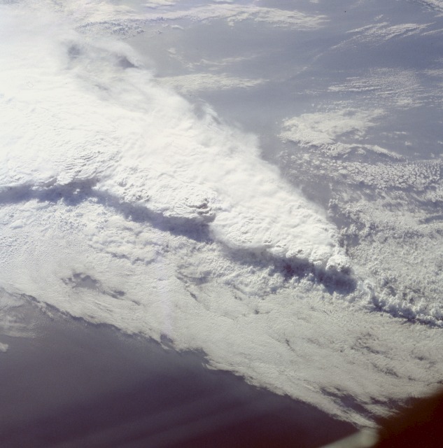 |
| STS41C-40-2130 Frontal System and Thunderstorms, Florida, U.S.A. April 1984 This spectacular, low-oblique photograph shows a convective line of thunderstorms associated with a passing cold front over Florida. A shadow from the height of the thunderstorms, caused by early morning sunlight, can be seen traversing the scene southwest to northeast. Some of these storms were estimated to reach heights in excess of 40 000 feet (12 000 meters). The V-shaped cloud structure is normally associated with cold fronts that cross the Gulf of Mexico and Florida in late winter and early spring. Severe thunderstorms and tornadoes usually occur with this type of storm system. At the time this photograph was taken, weather stations across Florida reported severe thunderstorms, strong winds, hail, torrential rains, and numerous tornadoes. |
| Images: | Images: | NO IMAGES YET | |||
| Mission: | STS41C |
||||
| Roll - Frame: | 40 - 2130 |
||||
| Geographical Name: | GULF OF MEXICO |
||||
| Features: | CLOUDS, FRONTAL SYSTEM |
||||
| Center Lat x Lon: | 28.0N x 84W |
||||
| Film Exposure: | N | N=Normal exposure, U=Under exposed, O=Over exposed, F=out of Focus |
|||
| Percentage of Cloud Cover-CLDP: | 80 |
||||
| Camera:: | HB |
||||
| Camera Tilt: | LO | LO=Low Oblique, HO=High Oblique, NV=Near Vertical |
|||
| Camera Focal Length: | 100 |
||||
| Nadir to Photo Center Direction: | The direction from the nadir to the center point, N=North, S=South, E=East, W=West |
||||
| Stereo?: | Y | Y=Yes there is an adjacent picture of the same area, N=No there isn't |
|||
| Orbit Number: | 47 |
||||
| Date: | 198404__ | YYYYMMDD |
|||
| Time: | GMT HHMMSS |
||||
| Nadir Lat: | N |
Latitude of suborbital point of spacecraft | |||
| Nadir Lon: | E |
Longitude of suborbital point of spacecraft | |||
| Sun Azimuth: | Clockwise angle in degrees from north to the sun measured at the nadir point |
||||
| Space Craft Altitude: | nautical miles |
||||
| Sun Elevation: | Angle in degrees between the horizon and the sun, measured at the nadir point |
||||
| Land Views: | |
||||
| Water Views: | |
||||
| Atmosphere Views: | THUNDERSTORM, SQUALL LINE |
||||
| Man Made Views: | |
||||
| City Views: | |
||||
Photo is not associated with any sequences | |||||
| NASA Home Page |
JSC Home Page |
JSC Digital Image Collection |
Earth Science & Remote Sensing |
|
This service is provided by the International Space Station program and the JSC Earth Science & Remote Sensing Unit, ARES Division, Exploration Integration Science Directorate.

|