
Geographic Region: PARAGUAY
Feature: RIO PARANA
|
Geographic Region: PARAGUAY Feature: RIO PARANA |
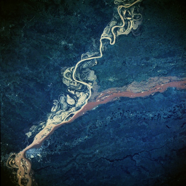 |
| STS41B-42-2483 Parana River, Argentina and Paraguay February 1984 The effects of the rainy season in south-central South America are vividly documented in this near-vertical photograph of the confluence of the Parana and Paraguay Rivers northeast of the Argentine town of Corrientes. The Parana River flows westward; after merging with the Paraguay River, it begins to flow almost due south. Both rivers are sediment laden and appear to be out of their normal watercourses, thereby producing flooding conditions. The Paraguay River is characterized by the widely varying, meandering main channel; many oxbow lakes; and a tan sediment load. The Parana River has a smaller floodplain, a deeper channel, and a reddish-brown sediment load. As the two rivers merge and begin to flow southwestward, their individual sediment patterns do not mix readily, a common occurrence in which rivers with different densities of suspended particles tend to retain their individual color characteristics for many miles downstream. The Parana River, which flows approximately 2000 miles (3200 kilometers), is the second largest drainage system in South America; the Amazon River is the largest. An old river channel south of the Parana River parallels the present river channel. This much older stream channel seems to flow toward the city of Corrientes (estimated population of 200 000), the commercial center for this rich agricultural region of northeast Argentina and southwest Paraguay. |
| Images: | All Available Images Low-Resolution 134k |
|
| Mission: | STS41B |
|
| Roll - Frame: | 42 - 2483 |
|
| Geographical Name: | PARAGUAY |
|
| Features: | RIO PARANA |
|
| Center Lat x Lon: | 27.5S x 58.5W |
|
| Film Exposure: | N | N=Normal exposure, U=Under exposed, O=Over exposed, F=out of Focus |
| Percentage of Cloud Cover-CLDP: | 0 |
|
| Camera:: | HB |
|
| Camera Tilt: | NV | LO=Low Oblique, HO=High Oblique, NV=Near Vertical |
| Camera Focal Length: | 250 |
|
| Nadir to Photo Center Direction: | The direction from the nadir to the center point, N=North, S=South, E=East, W=West |
|
| Stereo?: | Y | Y=Yes there is an adjacent picture of the same area, N=No there isn't |
| Orbit Number: | 53 |
|
| Date: | 198402__ | YYYYMMDD |
| Time: | GMT HHMMSS |
|
| Nadir Lat: | N |
Latitude of suborbital point of spacecraft |
| Nadir Lon: | E |
Longitude of suborbital point of spacecraft |
| Sun Azimuth: | Clockwise angle in degrees from north to the sun measured at the nadir point |
|
| Space Craft Altitude: | nautical miles |
|
| Sun Elevation: | Angle in degrees between the horizon and the sun, measured at the nadir point |
|
| Land Views: | PLAIN |
|
| Water Views: | RIVER, SEDIMENT |
|
| Atmosphere Views: | |
|
| Man Made Views: | URBAN AREA |
|
| City Views: | |
|
Photo is not associated with any sequences | ||
| NASA Home Page |
JSC Home Page |
JSC Digital Image Collection |
Earth Science & Remote Sensing |
|
This service is provided by the International Space Station program and the JSC Earth Science & Remote Sensing Unit, ARES Division, Exploration Integration Science Directorate.

|