Geographic Region: ETHIOPIA
Feature: AHMAR MOUNTAINS, SMOKE
|
Geographic Region: ETHIOPIA Feature: AHMAR MOUNTAINS, SMOKE |
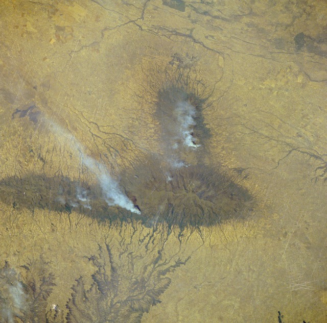 |
| STS41B-041-2405 Volcanic Mountains, Ethiopia February 1984 The East African Rift Valley extends generally northeast-southwest through the midsection of Ethiopia. The extreme eastern fringe of this graben valley just east of Lake Ziway is visible along the western margin of the photograph. The entire scene, including the visually imposing volcanic mountains, is almost in the geographic center of Ethiopia. The elongated volcanic mountainous structure has several peaks that exceed 12 000 feet (3660 meters), and the circular volcano to the west with its radial drainage pattern reaches an elevation of 13 140 feet (4005 meters) above sea level. The major drainage pattern on the eastern flank of the elongated mountain flows through deep and tortuous gorges as the water heads for the deserts of Somalia. Several smoke plumes rise from the forested slopes of the mountains. Burning is probably occurring to clear more land for subsistence agriculture, which is practiced in this region. |
| Images: | All Available Images Low-Resolution 141k |
|
| Mission: | STS41B |
|
| Roll - Frame: | 41 - 2405 |
|
| Geographical Name: | ETHIOPIA |
|
| Features: | AHMAR MOUNTAINS, SMOKE |
|
| Center Lat x Lon: | 8.0N x 39.5E |
|
| Film Exposure: | N | N=Normal exposure, U=Under exposed, O=Over exposed, F=out of Focus |
| Percentage of Cloud Cover-CLDP: | 0 |
|
| Camera:: | HB |
|
| Camera Tilt: | LO=Low Oblique, HO=High Oblique, NV=Near Vertical |
|
| Camera Focal Length: | 250 |
|
| Nadir to Photo Center Direction: | The direction from the nadir to the center point, N=North, S=South, E=East, W=West |
|
| Stereo?: | N | Y=Yes there is an adjacent picture of the same area, N=No there isn't |
| Orbit Number: | 30 |
|
| Date: | 198402__ | YYYYMMDD |
| Time: | GMT HHMMSS |
|
| Nadir Lat: | N |
Latitude of suborbital point of spacecraft |
| Nadir Lon: | E |
Longitude of suborbital point of spacecraft |
| Sun Azimuth: | Clockwise angle in degrees from north to the sun measured at the nadir point |
|
| Space Craft Altitude: | nautical miles |
|
| Sun Elevation: | Angle in degrees between the horizon and the sun, measured at the nadir point |
|
| Land Views: | ESCARPMENT, MOUNTAIN, VALLEY |
|
| Water Views: | RIVER |
|
| Atmosphere Views: | SMOKE |
|
| Man Made Views: | |
|
| City Views: | |
|
Photo is not associated with any sequences | ||
| NASA Home Page |
JSC Home Page |
JSC Digital Image Collection |
Earth Science & Remote Sensing |
|
This service is provided by the International Space Station program and the JSC Earth Science & Remote Sensing Unit, ARES Division, Exploration Integration Science Directorate.

|