
Geographic Region: BAHAMAS
Feature: BIGHT OF ACKLINS BAY
|
Geographic Region: BAHAMAS Feature: BIGHT OF ACKLINS BAY |
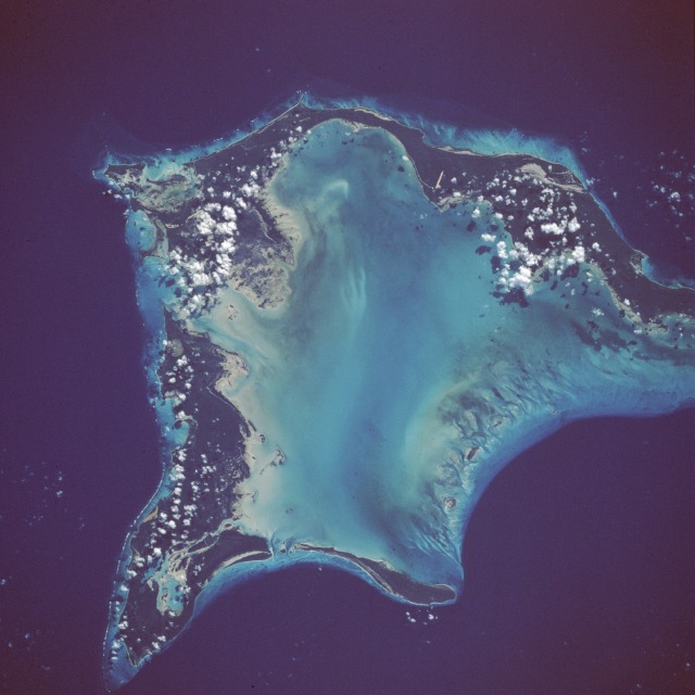 |
| STS41B-39-2159 Crooked Island and Acklins Island, Bahamas February 1984 Two of the many islands that make up the Bahamas are highlighted in this near-vertical photograph--Crooked Island to the northwest, separated by the Bight of Acklins from Acklins Island, the elongated, eastward island. The Bahamas comprise a dramatic combination of carbonate banks, islands, and deep water channels that have built up during the past 70 million years. Coral and algal reefs abound in the warm, shallow water. The strikingly different shades of blue provide a wealth of information about the water--the lighter shades, for example, show a variety of features within the very shallow waters, including constantly changing small banks, channels, ripples, shoals, grass, and algal beds. The dropoff from the shallow depths of generally less than 50 feet (15 meters) to depths exceeding 1000 feet (300 meters), represented by the darker blue, is abrupt and precipitous. Clarity of the water throughout the Bahamas primarily results from their distance from continental sediment sources. These two islands have not experienced the fairly rapid economic, tourist-related growth that many of the other Bahamas have experienced; however, several roads and two airport runways are visible. |
| Images: | All Available Images Low-Resolution 85k |
|
| Mission: | STS41B |
|
| Roll - Frame: | 39 - 2159 |
|
| Geographical Name: | BAHAMAS |
|
| Features: | BIGHT OF ACKLINS BAY |
|
| Center Lat x Lon: | 22.5N x 74W |
|
| Film Exposure: | N | N=Normal exposure, U=Under exposed, O=Over exposed, F=out of Focus |
| Percentage of Cloud Cover-CLDP: | 5 |
|
| Camera:: | HB |
|
| Camera Tilt: | NV | LO=Low Oblique, HO=High Oblique, NV=Near Vertical |
| Camera Focal Length: | 250 |
|
| Nadir to Photo Center Direction: | The direction from the nadir to the center point, N=North, S=South, E=East, W=West |
|
| Stereo?: | N | Y=Yes there is an adjacent picture of the same area, N=No there isn't |
| Orbit Number: | 18 |
|
| Date: | 198402__ | YYYYMMDD |
| Time: | GMT HHMMSS |
|
| Nadir Lat: | N |
Latitude of suborbital point of spacecraft |
| Nadir Lon: | E |
Longitude of suborbital point of spacecraft |
| Sun Azimuth: | Clockwise angle in degrees from north to the sun measured at the nadir point |
|
| Space Craft Altitude: | nautical miles |
|
| Sun Elevation: | Angle in degrees between the horizon and the sun, measured at the nadir point |
|
| Land Views: | ISLAND |
|
| Water Views: | LAGOON, OCEAN, REEF |
|
| Atmosphere Views: | |
|
| Man Made Views: | AIRPORT |
|
| City Views: | |
|
Photo is not associated with any sequences | ||
| NASA Home Page |
JSC Home Page |
JSC Digital Image Collection |
Earth Science & Remote Sensing |
|
This service is provided by the International Space Station program and the JSC Earth Science & Remote Sensing Unit, ARES Division, Exploration Integration Science Directorate.

|