 Photo #: STS131-E-12035 Date: Apr. 2010
Geographic Region: AUSTRALIA-SA
Feature: PAN, LAKE GAIRDNER,PORT AUGUSTA,SPACE SHUTTLE DISCOVERY
|
Photo #: STS131-E-12035 Date: Apr. 2010 Geographic Region: AUSTRALIA-SA Feature: PAN, LAKE GAIRDNER,PORT AUGUSTA,SPACE SHUTTLE DISCOVERY |
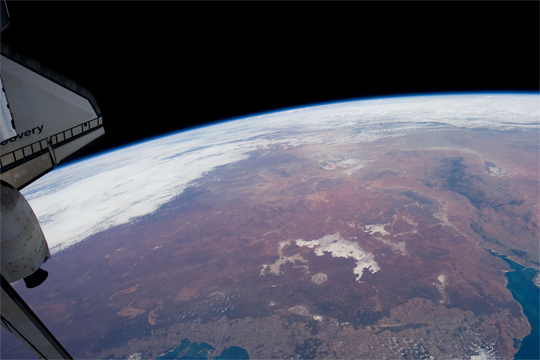 |
| Orbital View of Earth from Docked Shuttle Discovery The International Space Station orbits 354 kilometers (220 miles) above the Earth, completing one trip around the globe every 92 minutes. Cruising along at 27,700 km (17,200 miles) per hour, the astronauts experience 15 or 16 sunrises and -sets every day. Since the launch of the Zarya Control Module on November 20, 1998, the station has orbited the Earth over 66,500 times (as of June 27, 2010). The station's orbit is inclined to the equator by 51.65deg, meaning at its most northerly, it is at the latitude of London, England, and at it most southerly it is over the latitude of the Falkland Islands. This view features the arid interior of Australia colored myriad shades of red. At image top center,the white expanse of Lake Gairdner - the fourth largest salt lake in Australia when wet, and a large salt flat when dry - is visible. |
| Images: | All Available Images Low-Resolution 142k |
|
| Mission: | STS131 |
|
| Roll - Frame: | E - 12035 |
|
| Geographical Name: | AUSTRALIA-SA |
|
| Features: | PAN, LAKE GAIRDNER,PORT AUGUSTA,SPACE SHUTTLE DISCOVERY |
|
| Center Lat x Lon: | 29.5S x 137.5E |
|
| Film Exposure: | N=Normal exposure, U=Under exposed, O=Over exposed, F=out of Focus |
|
| Percentage of Cloud Cover-CLDP: | 50 |
|
| Camera:: | N3 |
|
| Camera Tilt: | HO | LO=Low Oblique, HO=High Oblique, NV=Near Vertical |
| Camera Focal Length: | 22 |
|
| Nadir to Photo Center Direction: | N | The direction from the nadir to the center point, N=North, S=South, E=East, W=West |
| Stereo?: | Y=Yes there is an adjacent picture of the same area, N=No there isn't |
|
| Orbit Number: | 107 |
|
| Date: | 20100412 | YYYYMMDD |
| Time: | 055450 | GMT HHMMSS |
| Nadir Lat: | 35.8S |
Latitude of suborbital point of spacecraft |
| Nadir Lon: | 134.6E |
Longitude of suborbital point of spacecraft |
| Sun Azimuth: | 309 | Clockwise angle in degrees from north to the sun measured at the nadir point |
| Space Craft Altitude: | 188 | nautical miles |
| Sun Elevation: | 30 | Angle in degrees between the horizon and the sun, measured at the nadir point |
| Land Views: | GLOBE |
|
| Water Views: | LAKE |
|
| Atmosphere Views: | |
|
| Man Made Views: | |
|
| City Views: | LONDON |
|
Photo is not associated with any sequences | ||
| NASA Home Page |
JSC Home Page |
JSC Digital Image Collection |
Earth Science & Remote Sensing |
|
This service is provided by the International Space Station program and the JSC Earth Science & Remote Sensing Unit, ARES Division, Exploration Integration Science Directorate.

|