
Geographic Region: MEXICO
Feature: PUERTO SAN CARLOS, C. SAN LAZARO, MAGDALENA BAY
|
Geographic Region: MEXICO Feature: PUERTO SAN CARLOS, C. SAN LAZARO, MAGDALENA BAY |
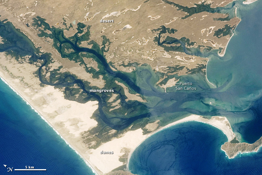 |
| Mangroves, Dunes, and Desert on Baja California Along the west coast of Baja California, roughly one third of the peninsula's length from its southern tip, the land pokes westward like a slightly bent elbow. The area is a combination of sparsely vegetated desert, sand dunes, mangroves, braided streams, shallow coastal waters, and mountainous islands. In this astronaut photograph, taken from a vantage point west of the peninsula, north is toward the upper left. Toward the east, the desert appears in shades of tan and beige. Blue-green mangroves infiltrate the desert, following irregular paths toward the northeast. Within these mangroves, deep blue streams and rivers form and flow toward the shallow waters near the coast. Along the Pacific shore (image lower left), breaking waves form an irregular white line. The waves are barely lighter than the sand dunes of the broad coastal plain, which stretches inland toward the mangroves. West of the mangroves, two islands rise above the ocean surface. Their rugged topography contrasts sharply with that of the thin, curving barrier beach that connects them. Almost completely surrounded by ocean, the coastal town of Puerto San Carlos serves as a base for tourists visiting the area to watch whales. Grey whale migration season--January through March--brings both cetaceans and tourists to the area. |
| Images: | All Available Images Low-Resolution 214k |
|
| Mission: | STS129 |
|
| Roll - Frame: | E - 6916 |
|
| Geographical Name: | MEXICO |
|
| Features: | PUERTO SAN CARLOS, C. SAN LAZARO, MAGDALENA BAY |
|
| Center Lat x Lon: | 24.8N x 112.1W |
|
| Film Exposure: | N=Normal exposure, U=Under exposed, O=Over exposed, F=out of Focus |
|
| Percentage of Cloud Cover-CLDP: | 10 |
|
| Camera:: | N2 |
|
| Camera Tilt: | 12 | LO=Low Oblique, HO=High Oblique, NV=Near Vertical |
| Camera Focal Length: | 125 |
|
| Nadir to Photo Center Direction: | S | The direction from the nadir to the center point, N=North, S=South, E=East, W=West |
| Stereo?: | Y=Yes there is an adjacent picture of the same area, N=No there isn't |
|
| Orbit Number: | 65 |
|
| Date: | 20091120 | YYYYMMDD |
| Time: | 194351 | GMT HHMMSS |
| Nadir Lat: | 25.4N |
Latitude of suborbital point of spacecraft |
| Nadir Lon: | 111.9W |
Longitude of suborbital point of spacecraft |
| Sun Azimuth: | 190 | Clockwise angle in degrees from north to the sun measured at the nadir point |
| Space Craft Altitude: | 180 | nautical miles |
| Sun Elevation: | 44 | Angle in degrees between the horizon and the sun, measured at the nadir point |
| Land Views: | COAST, DESERT, PENINSULA, PLAIN |
|
| Water Views: | OCEAN |
|
| Atmosphere Views: | |
|
| Man Made Views: | |
|
| City Views: | |
|
Photo is not associated with any sequences | ||
| NASA Home Page |
JSC Home Page |
JSC Digital Image Collection |
Earth Science & Remote Sensing |
|
This service is provided by the International Space Station program and the JSC Earth Science & Remote Sensing Unit, ARES Division, Exploration Integration Science Directorate.

|