 Photo #: STS117-E-6998 Date: Jun. 2007
Geographic Region: CLOUDS
Feature: POLAR MESOSPHERIC CLOUDS
|
Photo #: STS117-E-6998 Date: Jun. 2007 Geographic Region: CLOUDS Feature: POLAR MESOSPHERIC CLOUDS |
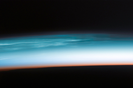 |
| Polar Mesospheric Clouds In the summertime in the far northern or southern latitudes, high in the Earth's atmosphere at the edge of space, thin, silvery clouds sometimes become visible just after sunset. These high clouds, occurring at altitudes of about 80 kilometers (50 miles), are called polar mesospheric clouds (PMCs). They are also called noctilucent ("night-shining") clouds. In recent years, polar mesospheric clouds seem to be occurring more frequently and at lower latitudes than they have in the past, and studies are underway to determine whether their occurrence is related to global climate change. In June 2007, the Space Shuttle crew visiting the International Space Station (ISS) observed spectacular polar mesospheric clouds over north-central Asia (top). This image was taken looking north while the Shuttle and ISS were docking and flying over the border between western China, Mongolia, and Kazakhstan. The red-to-dark region at the bottom of the image is the dense part of the Earth's atmosphere. Because this image was taken with a long lens (180mm), the entire profile of the Earth's limb (the edge of the atmosphere) was not captured. Astronauts frequently observe polar mesospheric clouds over Canada, northern Europe, and Asia during June, July and August. While polar mesospheric clouds also occur over high latitudes in the Southern Hemisphere summer, astronaut observations of southern clouds are less frequent. Studies of polar mesospheric clouds are part of the research activities for the International Polar Year (IPY); to support IPY research, ISS astronauts will be looking for and documenting polar mesospheric clouds in both hemispheres. NASA's AIM (short for "Aeronomy of Ice in the Mesosphere") mission is also studying polar mesospheric clouds. |
| Images: | All Available Images Low-Resolution 123k |
|
| Mission: | STS117 |
|
| Roll - Frame: | E - 6998 |
|
| Geographical Name: | CLOUDS |
|
| Features: | POLAR MESOSPHERIC CLOUDS |
|
| Center Lat x Lon: | N x E |
|
| Film Exposure: | N=Normal exposure, U=Under exposed, O=Over exposed, F=out of Focus |
|
| Percentage of Cloud Cover-CLDP: | 0 |
|
| Camera:: | E4 |
|
| Camera Tilt: | HO | LO=Low Oblique, HO=High Oblique, NV=Near Vertical |
| Camera Focal Length: | 180 |
|
| Nadir to Photo Center Direction: | The direction from the nadir to the center point, N=North, S=South, E=East, W=West |
|
| Stereo?: | Y=Yes there is an adjacent picture of the same area, N=No there isn't |
|
| Orbit Number: | 30 |
|
| Date: | 20070610 | YYYYMMDD |
| Time: | 191140 | GMT HHMMSS |
| Nadir Lat: | 41.5N |
Latitude of suborbital point of spacecraft |
| Nadir Lon: | 86.0E |
Longitude of suborbital point of spacecraft |
| Sun Azimuth: | 14 | Clockwise angle in degrees from north to the sun measured at the nadir point |
| Space Craft Altitude: | 181 | nautical miles |
| Sun Elevation: | -24 | Angle in degrees between the horizon and the sun, measured at the nadir point |
| Land Views: | |
|
| Water Views: | ICE |
|
| Atmosphere Views: | NOCTILUCENT CLOUDS |
|
| Man Made Views: | |
|
| City Views: | |
|
Photo is not associated with any sequences | ||
| NASA Home Page |
JSC Home Page |
JSC Digital Image Collection |
Earth Science & Remote Sensing |
|
This service is provided by the International Space Station program and the JSC Earth Science & Remote Sensing Unit, ARES Division, Exploration Integration Science Directorate.

|