
Geographic Region: ROMANIA
Feature: CONSTANTA, PORT FACILITIES
|
Geographic Region: ROMANIA Feature: CONSTANTA, PORT FACILITIES |
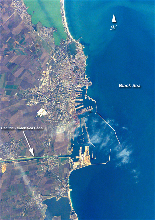 |
| The modern city of Constanta, with a population of more than 348,000, is located on the western coast of the Black Sea and is the principal seaport for Romania. It is the site of the ancient Greek city of Tomis, colonized in the 6th century B.C. In the 1st century A.D. Tomis became a flourishing provincial capital of the Roman Empire when it acquired its current name from the emperor Constantine I. Today, Constanta is a thriving port-of-entry for Romania, offering both tourist attractions and an expanding, modern port facility that is among the largest on the Black Sea. The crew of STS-112 acquired this detailed digital image of the city on October 17, 2002, using a 400-mm lens. The older part of the city is situated near the large coastal lagoon to the north, while to the south the port facilities are connected to the Danube River's import shipping commerce via the 64-km Danube - Black Sea Canal. Agricultural fields of mostly wheat and barley extend almost to the shorelines. |
| Images: | All Available Images Low-Resolution 248k |
|
| Mission: | STS112 |
|
| Roll - Frame: | E - 6329 |
|
| Geographical Name: | ROMANIA |
|
| Features: | CONSTANTA, PORT FACILITIES |
|
| Center Lat x Lon: | 44.0N x 28.5E |
|
| Film Exposure: | N=Normal exposure, U=Under exposed, O=Over exposed, F=out of Focus |
|
| Percentage of Cloud Cover-CLDP: | 10 |
|
| Camera:: | E4 |
|
| Camera Tilt: | 32 | LO=Low Oblique, HO=High Oblique, NV=Near Vertical |
| Camera Focal Length: | 400 |
|
| Nadir to Photo Center Direction: | SE | The direction from the nadir to the center point, N=North, S=South, E=East, W=West |
| Stereo?: | Y=Yes there is an adjacent picture of the same area, N=No there isn't |
|
| Orbit Number: | 152 |
|
| Date: | 20021017 | YYYYMMDD |
| Time: | 103812 | GMT HHMMSS |
| Nadir Lat: | 45.7N |
Latitude of suborbital point of spacecraft |
| Nadir Lon: | 27.3E |
Longitude of suborbital point of spacecraft |
| Sun Azimuth: | 193 | Clockwise angle in degrees from north to the sun measured at the nadir point |
| Space Craft Altitude: | 202 | nautical miles |
| Sun Elevation: | 34 | Angle in degrees between the horizon and the sun, measured at the nadir point |
| Land Views: | COAST |
|
| Water Views: | CANAL, LAGOON, SEA |
|
| Atmosphere Views: | |
|
| Man Made Views: | PORT |
|
| City Views: | CONSTANTA |
|
Photo is not associated with any sequences | ||
| NASA Home Page |
JSC Home Page |
JSC Digital Image Collection |
Earth Science & Remote Sensing |
|
This service is provided by the International Space Station program and the JSC Earth Science & Remote Sensing Unit, ARES Division, Exploration Integration Science Directorate.

|