
Geographic Region: RUSSIAN FEDERATION
Feature: MT. KAZBEK, KOLKA GLACIER COLLAPSE
|
Geographic Region: RUSSIAN FEDERATION Feature: MT. KAZBEK, KOLKA GLACIER COLLAPSE |
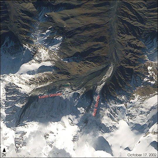 |
| STS112-E-6002 Caucasus Range While docked to the Space Station the international crew of Space Shuttle Mission STS-112 paused as the spacecraft sped over the Caucasus Range. They had planned before launch that a crewmember would look out the windows of the spacecraft for remnants of the disastrous collapse of Kolka Glacier. The close collaboration between the USA and Russia on all aspects of Space Station construction, and the presence on the Shuttle crew of Russian mission specialist Fyodor Yurchikhin, made the crew particularly interested in photographing the area to help scientists on the ground in their studies of the collapse. There is a dramatic difference between this digital photograph taken by the Shuttle crew and one taken just a week before the collapse by the International Space Station crew. The debris from Kolka glacier obscures and covers the terminus of Maili glacier. The far northern path of the Genaldon River is filled with debris, compared to the clear river course that could be seen before. The disaster claimed an estimated 140 lives when it sent 20 million tons of ice, rock and mud down Karmadon Gorge on September 20, 2002. The debris field stretches over 11 miles long and 820 feet wide, and according to the New York Times, will take as long as 10 years to thaw. |
| Images: | All Available Images Low-Resolution 109k |
|
| Mission: | STS112 |
|
| Roll - Frame: | E - 6002 |
|
| Geographical Name: | RUSSIAN FEDERATION |
|
| Features: | MT. KAZBEK, KOLKA GLACIER COLLAPSE |
|
| Center Lat x Lon: | 42.5N x 44.5E |
|
| Film Exposure: | N=Normal exposure, U=Under exposed, O=Over exposed, F=out of Focus |
|
| Percentage of Cloud Cover-CLDP: | 25 |
|
| Camera:: | E4 |
|
| Camera Tilt: | 32 | LO=Low Oblique, HO=High Oblique, NV=Near Vertical |
| Camera Focal Length: | 400 |
|
| Nadir to Photo Center Direction: | SW | The direction from the nadir to the center point, N=North, S=South, E=East, W=West |
| Stereo?: | Y=Yes there is an adjacent picture of the same area, N=No there isn't |
|
| Orbit Number: | 151 |
|
| Date: | 20021017 | YYYYMMDD |
| Time: | 090455 | GMT HHMMSS |
| Nadir Lat: | 43.8N |
Latitude of suborbital point of spacecraft |
| Nadir Lon: | 46.2E |
Longitude of suborbital point of spacecraft |
| Sun Azimuth: | 187 | Clockwise angle in degrees from north to the sun measured at the nadir point |
| Space Craft Altitude: | 202 | nautical miles |
| Sun Elevation: | 37 | Angle in degrees between the horizon and the sun, measured at the nadir point |
| Land Views: | GLACIER, RANGE |
|
| Water Views: | ICE |
|
| Atmosphere Views: | |
|
| Man Made Views: | |
|
| City Views: | |
|
Photo is not associated with any sequences | ||
| NASA Home Page |
JSC Home Page |
JSC Digital Image Collection |
Earth Science & Remote Sensing |
|
This service is provided by the International Space Station program and the JSC Earth Science & Remote Sensing Unit, ARES Division, Exploration Integration Science Directorate.

|