Geographic Region: INDONESIA
Feature: SANGEANG API
|
Geographic Region: INDONESIA Feature: SANGEANG API |
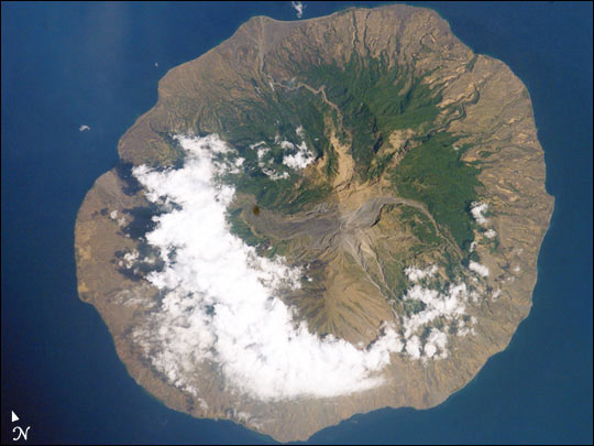 |
| In 1985, the small Indonesian island of Sangeang Api (for scale, the island is 13 km wide) off the northeast coast of Sumbawa began to erupt. Within a month, the 1250 inhabitants had evacuated to Sumbawa. The eruption lasted until 1988. The lava and pyroclastic flows--the wide channel running west from the summit--are still easily traced on this image taken last week by Space Shuttle astronauts (STS-112) . Today, the island's summit crater (1949 m) produces intermittent steam clouds. Compare this photograph to an earlier Space Shuttle photograph taken in November 1985. |
| Images: | All Available Images Low-Resolution 47k |
|
| Mission: | STS112 |
|
| Roll - Frame: | E - 5628 |
|
| Geographical Name: | INDONESIA |
|
| Features: | SANGEANG API |
|
| Center Lat x Lon: | 8S x 119.0E |
|
| Film Exposure: | N=Normal exposure, U=Under exposed, O=Over exposed, F=out of Focus |
|
| Percentage of Cloud Cover-CLDP: | 25 |
|
| Camera:: | E4 |
|
| Camera Tilt: | 16 | LO=Low Oblique, HO=High Oblique, NV=Near Vertical |
| Camera Focal Length: | 400 |
|
| Nadir to Photo Center Direction: | NW | The direction from the nadir to the center point, N=North, S=South, E=East, W=West |
| Stereo?: | Y=Yes there is an adjacent picture of the same area, N=No there isn't |
|
| Orbit Number: | 114 |
|
| Date: | 20021015 | YYYYMMDD |
| Time: | 012319 | GMT HHMMSS |
| Nadir Lat: | 8.7S |
Latitude of suborbital point of spacecraft |
| Nadir Lon: | 119.7E |
Longitude of suborbital point of spacecraft |
| Sun Azimuth: | 92 | Clockwise angle in degrees from north to the sun measured at the nadir point |
| Space Craft Altitude: | 205 | nautical miles |
| Sun Elevation: | 54 | Angle in degrees between the horizon and the sun, measured at the nadir point |
| Land Views: | COAST, VOLCANO, ISLAND |
|
| Water Views: | |
|
| Atmosphere Views: | |
|
| Man Made Views: | |
|
| City Views: | |
|
Photo is not associated with any sequences | ||
| NASA Home Page |
JSC Home Page |
JSC Digital Image Collection |
Earth Science & Remote Sensing |
|
This service is provided by the International Space Station program and the JSC Earth Science & Remote Sensing Unit, ARES Division, Exploration Integration Science Directorate.

|