
Geographic Region: USA-CALIFORNIA
Feature: SAN JOSE AREA, SALT PONDS
|
Geographic Region: USA-CALIFORNIA Feature: SAN JOSE AREA, SALT PONDS |
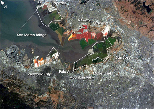 |
| The red and green colors of the salt ponds in South San Francisco Bay are brilliant visual markers for astronauts. The STS-111 crew photographed the bay south of the San Mateo bridge in June, 2002. This photograph is timely because a large number of the salt ponds (more than 16,500 acres) that are owned by Cargill, Inc. will be sold in September for wetlands restoration--a restoration project second in size only to the Florida Everglades project. Rough boundaries of the areas to be restored are outlined on the image. Over the past century, more than 80% of San Francisco Bay's wetlands have been filled and developed or diked off for salt mining. San Francisco Bay has supported salt mining since 1854. Cargill has operated most of the bay's commercial salt ponds since 1978, and had already sold thousands of acres to the State of California and the Don Edwards National Wildlife Refuge. This new transaction will increase San Francisco Bay's existing tidal wetlands by 50%. The new wetlands, to be managed by the California Department of Fish and Game and the U.S. Fish and Wildlife Service, will join the Don Edwards National Wildlife Refuge, and provide valuable habitat for birds, fish and other wildlife. The wetlands will contribute to better water quality and flood control in the bay, and open up more coastline for public enjoyment. |
| Images: | All Available Images Low-Resolution 73k |
|
| Mission: | STS111 |
|
| Roll - Frame: | 376 - 3 |
|
| Geographical Name: | USA-CALIFORNIA |
|
| Features: | SAN JOSE AREA, SALT PONDS |
|
| Center Lat x Lon: | 37.5N x 122W |
|
| Film Exposure: | N=Normal exposure, U=Under exposed, O=Over exposed, F=out of Focus |
|
| Percentage of Cloud Cover-CLDP: | 10 |
|
| Camera:: | NK |
|
| Camera Tilt: | 45 | LO=Low Oblique, HO=High Oblique, NV=Near Vertical |
| Camera Focal Length: | |
|
| Nadir to Photo Center Direction: | W | The direction from the nadir to the center point, N=North, S=South, E=East, W=West |
| Stereo?: | Y=Yes there is an adjacent picture of the same area, N=No there isn't |
|
| Orbit Number: | 188 |
|
| Date: | 20020617 | YYYYMMDD |
| Time: | 195341 | GMT HHMMSS |
| Nadir Lat: | 36.5N |
Latitude of suborbital point of spacecraft |
| Nadir Lon: | 119.1W |
Longitude of suborbital point of spacecraft |
| Sun Azimuth: | 176 | Clockwise angle in degrees from north to the sun measured at the nadir point |
| Space Craft Altitude: | 187 | nautical miles |
| Sun Elevation: | 77 | Angle in degrees between the horizon and the sun, measured at the nadir point |
| Land Views: | |
|
| Water Views: | BAY |
|
| Atmosphere Views: | |
|
| Man Made Views: | BRIDGE, MINING |
|
| City Views: | SAN JOSE |
|
Photo is not associated with any sequences | ||
| NASA Home Page |
JSC Home Page |
JSC Digital Image Collection |
Earth Science & Remote Sensing |
|
This service is provided by the International Space Station program and the JSC Earth Science & Remote Sensing Unit, ARES Division, Exploration Integration Science Directorate.

|