
Geographic Region: USA-WASHINGTON
Feature: MOUNT ST. HELENS, SPIRIT LAKE
|
Geographic Region: USA-WASHINGTON Feature: MOUNT ST. HELENS, SPIRIT LAKE |
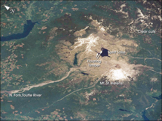 |
| STS111-371-3 Mt. St. Helens, Spirit Lake, Washington, USA June 2002 Snow still covered the peaks of the Cascade Ranges in mid-June when the STS-111 crew photographed Mt. St. Helens from the Space Shuttle Endeavour. From their vantage point, the crew observed blast zone from the 1980 eruption of the volcano, the mud-choked North Fork of the Toutle River, and fallen timber that still floats in rafts of logs on Spirit Lake. Continued imagery of the region will document the slow regrowth of the forests. Today, the volcano and surrounding region comprise the Mt. St. Helens National Volcanic Monument which is dedicated to research, education and recreation. |
| Images: | All Available Images Low-Resolution 70k |
|
| Mission: | STS111 |
|
| Roll - Frame: | 371 - 3 |
|
| Geographical Name: | USA-WASHINGTON |
|
| Features: | MOUNT ST. HELENS, SPIRIT LAKE |
|
| Center Lat x Lon: | 46.5N x 122W |
|
| Film Exposure: | N=Normal exposure, U=Under exposed, O=Over exposed, F=out of Focus |
|
| Percentage of Cloud Cover-CLDP: | 10 |
|
| Camera:: | NK |
|
| Camera Tilt: | 48 | LO=Low Oblique, HO=High Oblique, NV=Near Vertical |
| Camera Focal Length: | |
|
| Nadir to Photo Center Direction: | NE | The direction from the nadir to the center point, N=North, S=South, E=East, W=West |
| Stereo?: | Y=Yes there is an adjacent picture of the same area, N=No there isn't |
|
| Orbit Number: | 158 |
|
| Date: | 20020615 | YYYYMMDD |
| Time: | 220131 | GMT HHMMSS |
| Nadir Lat: | 44.4N |
Latitude of suborbital point of spacecraft |
| Nadir Lon: | 124.8W |
Longitude of suborbital point of spacecraft |
| Sun Azimuth: | 233 | Clockwise angle in degrees from north to the sun measured at the nadir point |
| Space Craft Altitude: | 190 | nautical miles |
| Sun Elevation: | 61 | Angle in degrees between the horizon and the sun, measured at the nadir point |
| Land Views: | VOLCANO |
|
| Water Views: | LAKE, RIVER |
|
| Atmosphere Views: | |
|
| Man Made Views: | |
|
| City Views: | |
|
Photo is not associated with any sequences | ||
| NASA Home Page |
JSC Home Page |
JSC Digital Image Collection |
Earth Science & Remote Sensing |
|
This service is provided by the International Space Station program and the JSC Earth Science & Remote Sensing Unit, ARES Division, Exploration Integration Science Directorate.

|