Geographic Region: NEW ZEALAND-NI
Feature: ROTORUA GEOTHERMAL
|
Geographic Region: NEW ZEALAND-NI Feature: ROTORUA GEOTHERMAL |
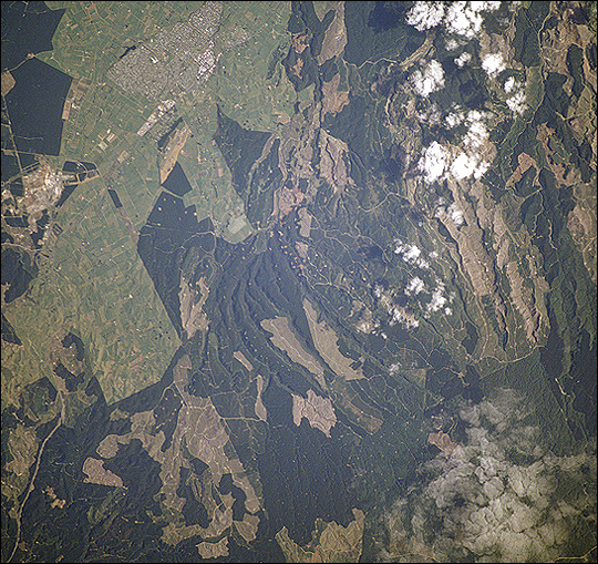 |
| Forests are being harvested near Tokoroa, New Zealand, which has been described as the hub of New Zealand's forestry industry. According to an Earth Observatory reader, the land use pattern that looks like tan beads on a string are clearings used to stock timber before it is sent to pulp and paper mills about 4 km south of Tokoroa. The light green areas around the town are dairy farms. |
| Images: | All Available Images Low-Resolution 279k |
|
| Mission: | STS110 |
|
| Roll - Frame: | 726 - 10 |
|
| Geographical Name: | NEW ZEALAND-NI |
|
| Features: | ROTORUA GEOTHERMAL |
|
| Center Lat x Lon: | 38S x 176.0E |
|
| Film Exposure: | N=Normal exposure, U=Under exposed, O=Over exposed, F=out of Focus |
|
| Percentage of Cloud Cover-CLDP: | 10 |
|
| Camera:: | HB |
|
| Camera Tilt: | 32 | LO=Low Oblique, HO=High Oblique, NV=Near Vertical |
| Camera Focal Length: | 110 |
|
| Nadir to Photo Center Direction: | SW | The direction from the nadir to the center point, N=North, S=South, E=East, W=West |
| Stereo?: | Y=Yes there is an adjacent picture of the same area, N=No there isn't |
|
| Orbit Number: | 18 |
|
| Date: | 20020409 | YYYYMMDD |
| Time: | 225622 | GMT HHMMSS |
| Nadir Lat: | 37.5S |
Latitude of suborbital point of spacecraft |
| Nadir Lon: | 176.8E |
Longitude of suborbital point of spacecraft |
| Sun Azimuth: | 26 | Clockwise angle in degrees from north to the sun measured at the nadir point |
| Space Craft Altitude: | 89 | nautical miles |
| Sun Elevation: | 41 | Angle in degrees between the horizon and the sun, measured at the nadir point |
| Land Views: | FOREST |
|
| Water Views: | |
|
| Atmosphere Views: | |
|
| Man Made Views: | |
|
| City Views: | |
|
Photo is not associated with any sequences | ||
| NASA Home Page |
JSC Home Page |
JSC Digital Image Collection |
Earth Science & Remote Sensing |
|
This service is provided by the International Space Station program and the JSC Earth Science & Remote Sensing Unit, ARES Division, Exploration Integration Science Directorate.

|