Geographic Region: CHILE
Feature: ICE FIELD, GLACIERS, LAKES
|
Geographic Region: CHILE Feature: ICE FIELD, GLACIERS, LAKES |
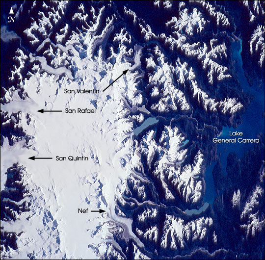 |
| The Northern Patagonian Ice Field (NPIF), centered near 47degS, 73.5degW, is the smaller of two remnant ice masses crowning the Andes Mountains of lower South America. The NPIF is a vestige of an extensive ice sheet that covered much of Patagonia just over a million years ago. Today, with its glaciers largely in retreat and only an area of 4,200 sq km, it is still the largest continuous mass of ice outside of the polar regions. Survival is based on its elevation (1, 100 to 1,500 m), favorable terrain, and a cool, moist, marine climate. The ice field has 28 exit glaciers, the largest two--San Quintin and San Rafael--nearly reach sea level to the west at the Pacific Ocean. Smaller exit glaciers, like San Valentin and Nef, feed numerous rivers and glacially carved lakes to the east. This photo taken by the crew of STS-108 in December, 2001, offers a remarkably clear view of the northern two-thirds of this bright, icy feature, its glaciers, and its northern and eastern flanks. Arms of Lake General Carrera are visible on the right of the image. Such photos offer unsurpassed visual context information about the state of this remote locale and details of its features and processes. |
| Images: | All Available Images Low-Resolution 115k |
|
| Mission: | STS108 |
|
| Roll - Frame: | 722 - 60 |
|
| Geographical Name: | CHILE |
|
| Features: | ICE FIELD, GLACIERS, LAKES |
|
| Center Lat x Lon: | 47S x 73.5W |
|
| Film Exposure: | N=Normal exposure, U=Under exposed, O=Over exposed, F=out of Focus |
|
| Percentage of Cloud Cover-CLDP: | 10 |
|
| Camera:: | HB |
|
| Camera Tilt: | HO | LO=Low Oblique, HO=High Oblique, NV=Near Vertical |
| Camera Focal Length: | 110 |
|
| Nadir to Photo Center Direction: | E | The direction from the nadir to the center point, N=North, S=South, E=East, W=West |
| Stereo?: | Y=Yes there is an adjacent picture of the same area, N=No there isn't |
|
| Orbit Number: | 166 |
|
| Date: | 20011216 | YYYYMMDD |
| Time: | 121002 | GMT HHMMSS |
| Nadir Lat: | 48.9S |
Latitude of suborbital point of spacecraft |
| Nadir Lon: | 80.9W |
Longitude of suborbital point of spacecraft |
| Sun Azimuth: | 97 | Clockwise angle in degrees from north to the sun measured at the nadir point |
| Space Craft Altitude: | 204 | nautical miles |
| Sun Elevation: | 26 | Angle in degrees between the horizon and the sun, measured at the nadir point |
| Land Views: | |
|
| Water Views: | ICE, LAKE |
|
| Atmosphere Views: | |
|
| Man Made Views: | |
|
| City Views: | |
|
Photo is not associated with any sequences | ||
| NASA Home Page |
JSC Home Page |
JSC Digital Image Collection |
Earth Science & Remote Sensing |
|
This service is provided by the International Space Station program and the JSC Earth Science & Remote Sensing Unit, ARES Division, Exploration Integration Science Directorate.

|