Geographic Region: MOROCCO
Feature: ANTI ATLAS MOUNTAINS
|
Geographic Region: MOROCCO Feature: ANTI ATLAS MOUNTAINS |
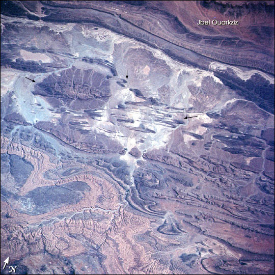 |
| The Anti-Atlas Mountains of northern Africa and the nearby Atlas mountains were created by the prolonged collision of the African and Eurasian tectonic plates, beginning about 80 million years ago. Massive sandstone and limestone layers have been crumpled and uplifted more than 4,000 meters in the High Atlas and to lower elevations in the Anti-Atlas. Between more continuous major fold structures, such as the Jbel Ouarkziz in the southwestern Anti-Atlas, tighter secondary folds (arrow) have developed. Earlier, the supercontinent of Pangea rifted apart to form precursors to the Mediterranean and the Atlantic Ocean (Beauchamp and others, 1996). In those seas sands, clays, limey sediments, and evaporite layers (gypsum, rock salt) were deposited. Later, during the mountain-building plate collision, the gypsum layers flowed under the pressure and provided a slippery surface on which overlying rigid rocks could glide (Burkhard, 2001). The broad, open style of folds seen in this view is common where evaporites are involved in the deformation. Other examples can be found in the Southern Zagros of Iran and the Sierra Madre Oriental of Mexico. |
| Images: | All Available Images Low-Resolution 101k |
|
| Mission: | STS108 |
|
| Roll - Frame: | 711 - 25 |
|
| Geographical Name: | MOROCCO |
|
| Features: | ANTI ATLAS MOUNTAINS |
|
| Center Lat x Lon: | 29.0N x 9W |
|
| Film Exposure: | N=Normal exposure, U=Under exposed, O=Over exposed, F=out of Focus |
|
| Percentage of Cloud Cover-CLDP: | 10 |
|
| Camera:: | HB |
|
| Camera Tilt: | 46 | LO=Low Oblique, HO=High Oblique, NV=Near Vertical |
| Camera Focal Length: | 110 |
|
| Nadir to Photo Center Direction: | N | The direction from the nadir to the center point, N=North, S=South, E=East, W=West |
| Stereo?: | Y=Yes there is an adjacent picture of the same area, N=No there isn't |
|
| Orbit Number: | 152 |
|
| Date: | 20011215 | YYYYMMDD |
| Time: | 133559 | GMT HHMMSS |
| Nadir Lat: | 25.6N |
Latitude of suborbital point of spacecraft |
| Nadir Lon: | 10.1W |
Longitude of suborbital point of spacecraft |
| Sun Azimuth: | 198 | Clockwise angle in degrees from north to the sun measured at the nadir point |
| Space Craft Altitude: | 207 | nautical miles |
| Sun Elevation: | 39 | Angle in degrees between the horizon and the sun, measured at the nadir point |
| Land Views: | MOUNTAIN |
|
| Water Views: | |
|
| Atmosphere Views: | |
|
| Man Made Views: | |
|
| City Views: | |
|
Photo is not associated with any sequences | ||
| NASA Home Page |
JSC Home Page |
JSC Digital Image Collection |
Earth Science & Remote Sensing |
|
This service is provided by the International Space Station program and the JSC Earth Science & Remote Sensing Unit, ARES Division, Exploration Integration Science Directorate.

|