
Geographic Region: ITALY
Feature: MOUNT VESUVIUS, NAPLES
|
Geographic Region: ITALY Feature: MOUNT VESUVIUS, NAPLES |
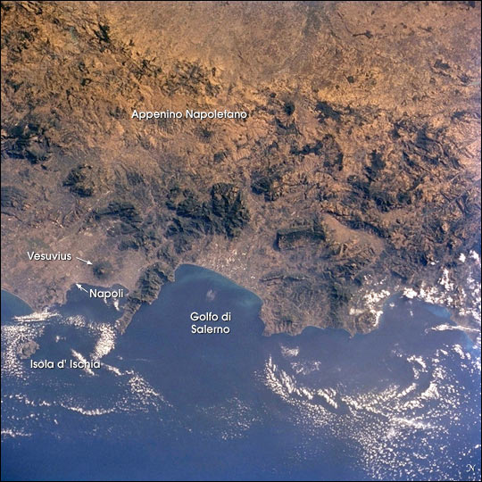 |
| For more than 240 million years the region now known as Italy has been the scene of episodic volcanic activity. East-southeast of Napoli (Naples) stands the imposing cone of Vesuvius, which erupted explosively in 79 A.D. to bury Pompeii and Herculaneum. More recently, when the crew of Space Shuttle mission STS-104 captured this view, Mt. Etna (Sicily, not seen in this image, but photographed the day before) was spewing ash and gas thousands of meters into the air, some of which can be seen as a brownish smear over Isola d' Ischia and the Tyrrhenian Sea. The Appenine ranges extend from northern Italy, down the boot of the peninsula and westward into Sicily. This photograph of the Appenino Napoletano is part of an 18-frame stereophoto mapping strip that spans the entire mountain chain. The almost 1200-km-long belt of volcanoes and folded/faulted mountains is a result of the ongoing collision of Africa and Eurasia, accompanied by the progressive closing of the Mediterranean Sea. Using overlapping pairs of stereophotos, and a special viewer, scientists can get a three-dimensional perspective on the ranges that surpasses any image viewed alone. |
| Images: | All Available Images Low-Resolution 97k |
|
| Mission: | STS104 |
|
| Roll - Frame: | 710 - 60 |
|
| Geographical Name: | ITALY |
|
| Features: | MOUNT VESUVIUS, NAPLES |
|
| Center Lat x Lon: | 41.0N x 15.0E |
|
| Film Exposure: | N=Normal exposure, U=Under exposed, O=Over exposed, F=out of Focus |
|
| Percentage of Cloud Cover-CLDP: | 10 |
|
| Camera:: | HB |
|
| Camera Tilt: | 19 | LO=Low Oblique, HO=High Oblique, NV=Near Vertical |
| Camera Focal Length: | 250 |
|
| Nadir to Photo Center Direction: | SE | The direction from the nadir to the center point, N=North, S=South, E=East, W=West |
| Stereo?: | Y=Yes there is an adjacent picture of the same area, N=No there isn't |
|
| Orbit Number: | 171 |
|
| Date: | 20010723 | YYYYMMDD |
| Time: | 054256 | GMT HHMMSS |
| Nadir Lat: | 42.0N |
Latitude of suborbital point of spacecraft |
| Nadir Lon: | 14.3E |
Longitude of suborbital point of spacecraft |
| Sun Azimuth: | 80 | Clockwise angle in degrees from north to the sun measured at the nadir point |
| Space Craft Altitude: | 210 | nautical miles |
| Sun Elevation: | 19 | Angle in degrees between the horizon and the sun, measured at the nadir point |
| Land Views: | MOUNTAIN, PENINSULA |
|
| Water Views: | SEA |
|
| Atmosphere Views: | |
|
| Man Made Views: | |
|
| City Views: | NAPLES, NAPOLI |
|
Photo is not associated with any sequences | ||
| NASA Home Page |
JSC Home Page |
JSC Digital Image Collection |
Earth Science & Remote Sensing |
|
This service is provided by the International Space Station program and the JSC Earth Science & Remote Sensing Unit, ARES Division, Exploration Integration Science Directorate.

|