
Geographic Region: EGYPT
Feature: ASWAN HIGH DAM, LAKE NASSER
|
Geographic Region: EGYPT Feature: ASWAN HIGH DAM, LAKE NASSER |
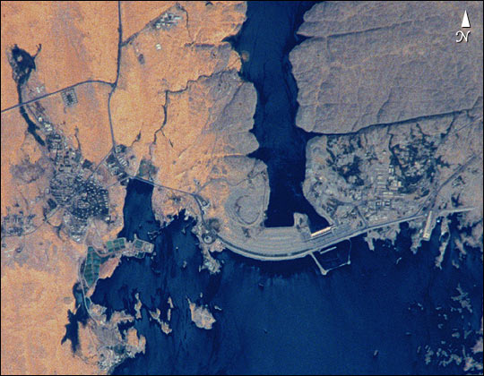 |
| STS102-303-17 Aswan High Dam, Egypt The Aswan High Dam was completed in 1970 and is one of the largest earthen embankment dams in the world. It is 364 feet (111 m) tall, 12 565 feet (3830 m) long and nearly 3281 feet (1000 m) wide. When it was built the new reservoir required relocation of nearly 100 000 residents and some archaeological sites. Although the reservoir has benefited Egypt by providing power and controlling floods, it has also had detrimental effects on the Nile system. Before the dam, an estimated 110 million tons of silt was deposited by the annual flood of the Nile, enriching agricultural lands and maintaining the land of the Nile delta. Now this sediment is trapped behind the dam, requiring artificial fertilization of agricultural lands and leading to erosion and saltwater intrusion where the Nile river meets the Mediterranean Sea. |
| Images: | All Available Images Low-Resolution 67k |
|
| Mission: | STS102 |
|
| Roll - Frame: | 303 - 17 |
|
| Geographical Name: | EGYPT |
|
| Features: | ASWAN HIGH DAM, LAKE NASSER |
|
| Center Lat x Lon: | 24.0N x 33.0E |
|
| Film Exposure: | N=Normal exposure, U=Under exposed, O=Over exposed, F=out of Focus |
|
| Percentage of Cloud Cover-CLDP: | 10 |
|
| Camera:: | NK |
|
| Camera Tilt: | 21 | LO=Low Oblique, HO=High Oblique, NV=Near Vertical |
| Camera Focal Length: | 110 |
|
| Nadir to Photo Center Direction: | SE | The direction from the nadir to the center point, N=North, S=South, E=East, W=West |
| Stereo?: | Y=Yes there is an adjacent picture of the same area, N=No there isn't |
|
| Orbit Number: | 156 |
|
| Date: | 20010318 | YYYYMMDD |
| Time: | 090921 | GMT HHMMSS |
| Nadir Lat: | 24.7N |
Latitude of suborbital point of spacecraft |
| Nadir Lon: | 31.9E |
Longitude of suborbital point of spacecraft |
| Sun Azimuth: | 152 | Clockwise angle in degrees from north to the sun measured at the nadir point |
| Space Craft Altitude: | 205 | nautical miles |
| Sun Elevation: | 62 | Angle in degrees between the horizon and the sun, measured at the nadir point |
| Land Views: | EROSION |
|
| Water Views: | RESERVOIR, RIVER |
|
| Atmosphere Views: | |
|
| Man Made Views: | DAM |
|
| City Views: | |
|
Photo is not associated with any sequences | ||
| NASA Home Page |
JSC Home Page |
JSC Digital Image Collection |
Earth Science & Remote Sensing |
|
This service is provided by the International Space Station program and the JSC Earth Science & Remote Sensing Unit, ARES Division, Exploration Integration Science Directorate.

|