
Geographic Region: USA-COLORADO
Feature: ROCKY MTS., SKI SLOPES, VAIL
|
Geographic Region: USA-COLORADO Feature: ROCKY MTS., SKI SLOPES, VAIL |
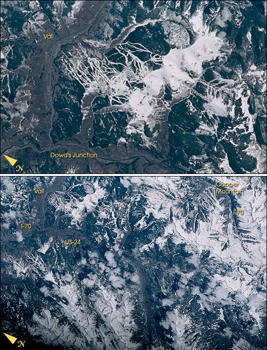 |
| The snow-covered ski runs of Vail, Colorado, look like white ribbons in contrast to the dark green forests of the Rocky Mountains. This detailed image is part of a larger view of area ski resorts photographed by the STS-100 Space Shuttle crew in April 2001. In the complete image, much of I-70 and U.S. Highway 24 can be distinguished. The numerous ski runs of Vail are in the upper left of the photo and Copper Mountain Resort is in the upper right. |
| Images: | All Available Images Low-Resolution 152k |
|
| Mission: | STS100 |
|
| Roll - Frame: | 349 - 9 |
|
| Geographical Name: | USA-COLORADO |
|
| Features: | ROCKY MTS., SKI SLOPES, VAIL |
|
| Center Lat x Lon: | 39.5N x 106.5W |
|
| Film Exposure: | N=Normal exposure, U=Under exposed, O=Over exposed, F=out of Focus |
|
| Percentage of Cloud Cover-CLDP: | 10 |
|
| Camera:: | NK |
|
| Camera Tilt: | LO | LO=Low Oblique, HO=High Oblique, NV=Near Vertical |
| Camera Focal Length: | |
|
| Nadir to Photo Center Direction: | The direction from the nadir to the center point, N=North, S=South, E=East, W=West |
|
| Stereo?: | Y=Yes there is an adjacent picture of the same area, N=No there isn't |
|
| Orbit Number: | |
|
| Date: | 200104__ | YYYYMMDD |
| Time: | GMT HHMMSS |
|
| Nadir Lat: | N |
Latitude of suborbital point of spacecraft |
| Nadir Lon: | E |
Longitude of suborbital point of spacecraft |
| Sun Azimuth: | Clockwise angle in degrees from north to the sun measured at the nadir point |
|
| Space Craft Altitude: | nautical miles |
|
| Sun Elevation: | Angle in degrees between the horizon and the sun, measured at the nadir point |
|
| Land Views: | MOUNTAIN |
|
| Water Views: | |
|
| Atmosphere Views: | |
|
| Man Made Views: | HIGHWAY |
|
| City Views: | VAIL |
|
Photo is not associated with any sequences | ||
| NASA Home Page |
JSC Home Page |
JSC Digital Image Collection |
Earth Science & Remote Sensing |
|
This service is provided by the International Space Station program and the JSC Earth Science & Remote Sensing Unit, ARES Division, Exploration Integration Science Directorate.

|