
Geographic Region: MYANMAR (BURMA)
Feature: CHINDWIN R.,ARAKAN HILLS
|
Geographic Region: MYANMAR (BURMA) Feature: CHINDWIN R.,ARAKAN HILLS |
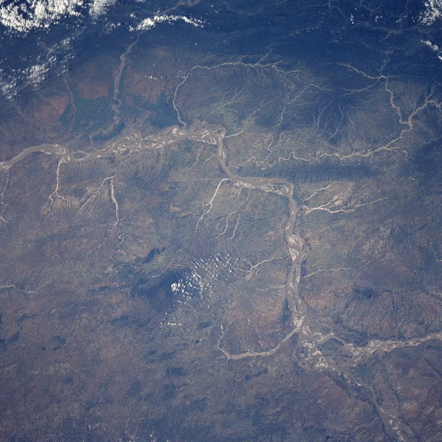 |
| STS095-721-0AT Irrawaddy River Basin, Myanmar November 1998 The Irrawaddy River, the chief river of Myanmar (Burma), enters the scene at the bottom right. The river flows in a generally southwest direction before turning to the south and exiting the scene midway between the upper left and center left of the view. In this scene, numerous sandbars are visible in the main river channel. The Irrawaddy's chief tributary, the Chindwin River, is discernible entering the Irrawaddy in the bottom right portion of the image. The Chindwin River is 550 miles (885km) long and rises in the Kumon Range in northern Myanmar. The dark area to the south of the Irrawaddy and just to the left of center of the image is the 5080 Foot (1518 meters) Popa Mountain, an extinct volcano. At the top of the image, many small streams can be seen emptying into the Irrawaddy from the forested Arakan Mountain Range. |
| Images: | All Available Images Low-Resolution 369k |
|
| Mission: | STS095 |
|
| Roll - Frame: | 721 - AT |
|
| Geographical Name: | MYANMAR (BURMA) |
|
| Features: | CHINDWIN R.,ARAKAN HILLS |
|
| Center Lat x Lon: | 21.0N x 95.0E |
|
| Film Exposure: | N | N=Normal exposure, U=Under exposed, O=Over exposed, F=out of Focus |
| Percentage of Cloud Cover-CLDP: | 5 |
|
| Camera:: | HB |
|
| Camera Tilt: | LO | LO=Low Oblique, HO=High Oblique, NV=Near Vertical |
| Camera Focal Length: | 250 |
|
| Nadir to Photo Center Direction: | The direction from the nadir to the center point, N=North, S=South, E=East, W=West |
|
| Stereo?: | Y | Y=Yes there is an adjacent picture of the same area, N=No there isn't |
| Orbit Number: | |
|
| Date: | 1998____ | YYYYMMDD |
| Time: | GMT HHMMSS |
|
| Nadir Lat: | N |
Latitude of suborbital point of spacecraft |
| Nadir Lon: | E |
Longitude of suborbital point of spacecraft |
| Sun Azimuth: | Clockwise angle in degrees from north to the sun measured at the nadir point |
|
| Space Craft Altitude: | nautical miles |
|
| Sun Elevation: | Angle in degrees between the horizon and the sun, measured at the nadir point |
|
| Land Views: | BASIN, HILL, EROSION |
|
| Water Views: | RIVER |
|
| Atmosphere Views: | |
|
| Man Made Views: | AGRICULTURE |
|
| City Views: | |
|
Photo is not associated with any sequences | ||
| NASA Home Page |
JSC Home Page |
JSC Digital Image Collection |
Earth Science & Remote Sensing |
|
This service is provided by the International Space Station program and the JSC Earth Science & Remote Sensing Unit, ARES Division, Exploration Integration Science Directorate.

|