Geographic Region: TAIWAN
Feature: TAINAN, TAITUNG, HAZE
|
Geographic Region: TAIWAN Feature: TAINAN, TAITUNG, HAZE |
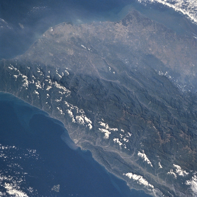 |
| STS095-712-022 Chungyang Mountains, Taiwan November 1998 A section of the rugged, steep sloped and densely forested Chungyang Mountains (dark, north-south aligned feature) can be identified in southern Taiwan. Maximum elevations in this section of the mountain range from slightly over 10000 feet (3048 meters) above sea level in the north (lower right) to less than 6000 feet (1830 meters) in the south (middle left edge). The southerly draining Peinan River Valley along the east coast (light-colored line-bottom center) and the southwesterly draining Chishan River (light-colored line-center of the image) can be traced through the mountainous terrain. The southwest coastal cities of Kaohsiung (upper left) and Tainan (upper center) can be seen through the hazy atmosphere that constantly plagues the highly industrialized and densely populated west coastal plain of Taiwan. |
| Images: | All Available Images Low-Resolution 354k |
|
| Mission: | STS095 |
|
| Roll - Frame: | 712 - 22 |
|
| Geographical Name: | TAIWAN |
|
| Features: | TAINAN, TAITUNG, HAZE |
|
| Center Lat x Lon: | 23.0N x 120.5E |
|
| Film Exposure: | N | N=Normal exposure, U=Under exposed, O=Over exposed, F=out of Focus |
| Percentage of Cloud Cover-CLDP: | 15 |
|
| Camera:: | HB |
|
| Camera Tilt: | 32 | LO=Low Oblique, HO=High Oblique, NV=Near Vertical |
| Camera Focal Length: | 250 |
|
| Nadir to Photo Center Direction: | NW | The direction from the nadir to the center point, N=North, S=South, E=East, W=West |
| Stereo?: | N | Y=Yes there is an adjacent picture of the same area, N=No there isn't |
| Orbit Number: | 50 |
|
| Date: | 19981102 | YYYYMMDD |
| Time: | 011552 | GMT HHMMSS |
| Nadir Lat: | 21.5N |
Latitude of suborbital point of spacecraft |
| Nadir Lon: | 123.2E |
Longitude of suborbital point of spacecraft |
| Sun Azimuth: | 135 | Clockwise angle in degrees from north to the sun measured at the nadir point |
| Space Craft Altitude: | 294 | nautical miles |
| Sun Elevation: | 41 | Angle in degrees between the horizon and the sun, measured at the nadir point |
| Land Views: | MOUNTAIN, FOREST, VALLEY |
|
| Water Views: | RIVER |
|
| Atmosphere Views: | |
|
| Man Made Views: | POLLUTION |
|
| City Views: | |
|
Photo is not associated with any sequences | ||
| NASA Home Page |
JSC Home Page |
JSC Digital Image Collection |
Earth Science & Remote Sensing |
|
This service is provided by the International Space Station program and the JSC Earth Science & Remote Sensing Unit, ARES Division, Exploration Integration Science Directorate.

|