
Geographic Region: USA-VIRGINIA
Feature: PAN-PAMLICO SOUND, COAST
|
Geographic Region: USA-VIRGINIA Feature: PAN-PAMLICO SOUND, COAST |
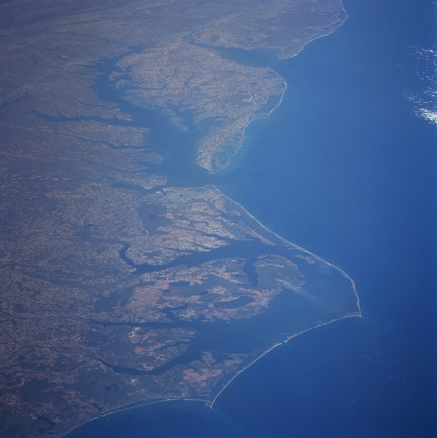 |
| STS095-709-014 Pan Mid-Atlantic Coast, United States October 1998 This photograph covers the mid-Atlantic Coast of the eastern United States from New Jersey (just to the right of top center of the image) southward to just southwest of Cape Lookout, North Carolina. Near the upper left of the image, the folded Appalachian Mountains of South-central Pennsylvania are discernible. Delaware Bay between the state of New Jersey to the north and the state Delaware is visible. The Delmarva Peninsula is discernible to the south of Delaware Bay. To the west of the Delmarva Peninsula is Chesapeake Bay. At the entrance to Chesapeake Bay, Cape Charles (north) and Cape Henry (south) can be seen. Capes Hatteras and Lookout and their barrier islands are visible in the bottom portion of the image. To the west of the Barrier Islands is Pamlico Sound. West of Pamlico Sound are agricultural fields of the coastal plain of North Carolina. |
| Images: | All Available Images Low-Resolution 298k |
|
| Mission: | STS095 |
|
| Roll - Frame: | 709 - 14 |
|
| Geographical Name: | USA-VIRGINIA |
|
| Features: | PAN-PAMLICO SOUND, COAST |
|
| Center Lat x Lon: | 37.0N x 76.5W |
|
| Film Exposure: | O | N=Normal exposure, U=Under exposed, O=Over exposed, F=out of Focus |
| Percentage of Cloud Cover-CLDP: | 5 |
|
| Camera:: | HB |
|
| Camera Tilt: | HO | LO=Low Oblique, HO=High Oblique, NV=Near Vertical |
| Camera Focal Length: | 250 |
|
| Nadir to Photo Center Direction: | N | The direction from the nadir to the center point, N=North, S=South, E=East, W=West |
| Stereo?: | N | Y=Yes there is an adjacent picture of the same area, N=No there isn't |
| Orbit Number: | 31 |
|
| Date: | 19981031 | YYYYMMDD |
| Time: | 191415 | GMT HHMMSS |
| Nadir Lat: | 27.7N |
Latitude of suborbital point of spacecraft |
| Nadir Lon: | 77.8W |
Longitude of suborbital point of spacecraft |
| Sun Azimuth: | 223 | Clockwise angle in degrees from north to the sun measured at the nadir point |
| Space Craft Altitude: | 295 | nautical miles |
| Sun Elevation: | 36 | Angle in degrees between the horizon and the sun, measured at the nadir point |
| Land Views: | COAST, PLAIN, PENINSULA |
|
| Water Views: | BAY |
|
| Atmosphere Views: | SMOKE |
|
| Man Made Views: | AGRICULTURE |
|
| City Views: | |
|
Photo is not associated with any sequences | ||
| NASA Home Page |
JSC Home Page |
JSC Digital Image Collection |
Earth Science & Remote Sensing |
|
This service is provided by the International Space Station program and the JSC Earth Science & Remote Sensing Unit, ARES Division, Exploration Integration Science Directorate.

|