
Geographic Region: USA-FLORIDA
Feature: TAMPA BAY AREA, LAKELAND
|
Geographic Region: USA-FLORIDA Feature: TAMPA BAY AREA, LAKELAND |
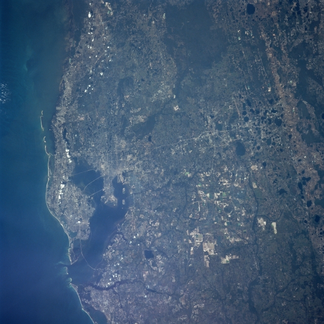 |
| STS095-704-074 Lakeland Area, Florida, USA November 1998 The heavily populated central west coast of the Florida peninsula, centered on Tampa Bay (top), include the urban areas of Tampa, St. Petersburg, and Clearwater in this westerly looking view that extends from the Gulf of Mexico to the karst topography inland. Interstate Highway 4 (light colored, linear feature) runs east and west across the center of the scene from Tampa Bay to the lakes inland at the bottom of the view. The dark, roughly oval features along the eastern (bottom) side of the picture are lakes that have formed in sinkholes that pockmark the underlying limestone rock. The highly reflective, angular surfaces towards the south central part of the picture are open pit phosphate mines. The extensive darker terrain along the north central edge (right) of the image is poorly drained swampland. |
| Images: | All Available Images Low-Resolution 336k |
|
| Mission: | STS095 |
|
| Roll - Frame: | 704 - 74 |
|
| Geographical Name: | USA-FLORIDA |
|
| Features: | TAMPA BAY AREA, LAKELAND |
|
| Center Lat x Lon: | 28.0N x 82.5W |
|
| Film Exposure: | N | N=Normal exposure, U=Under exposed, O=Over exposed, F=out of Focus |
| Percentage of Cloud Cover-CLDP: | 0 |
|
| Camera:: | HB |
|
| Camera Tilt: | LO | LO=Low Oblique, HO=High Oblique, NV=Near Vertical |
| Camera Focal Length: | 250 |
|
| Nadir to Photo Center Direction: | The direction from the nadir to the center point, N=North, S=South, E=East, W=West |
|
| Stereo?: | Y | Y=Yes there is an adjacent picture of the same area, N=No there isn't |
| Orbit Number: | |
|
| Date: | 1998____ | YYYYMMDD |
| Time: | GMT HHMMSS |
|
| Nadir Lat: | N |
Latitude of suborbital point of spacecraft |
| Nadir Lon: | E |
Longitude of suborbital point of spacecraft |
| Sun Azimuth: | Clockwise angle in degrees from north to the sun measured at the nadir point |
|
| Space Craft Altitude: | nautical miles |
|
| Sun Elevation: | Angle in degrees between the horizon and the sun, measured at the nadir point |
|
| Land Views: | COAST, PLAIN |
|
| Water Views: | BAY, LAKE, SWAMP |
|
| Atmosphere Views: | |
|
| Man Made Views: | HIGHWAY, MINING |
|
| City Views: | |
|
Photo is not associated with any sequences | ||
| NASA Home Page |
JSC Home Page |
JSC Digital Image Collection |
Earth Science & Remote Sensing |
|
This service is provided by the International Space Station program and the JSC Earth Science & Remote Sensing Unit, ARES Division, Exploration Integration Science Directorate.

|