
Geographic Region: USA-FLORIDA
Feature: MIAMI
|
Geographic Region: USA-FLORIDA Feature: MIAMI |
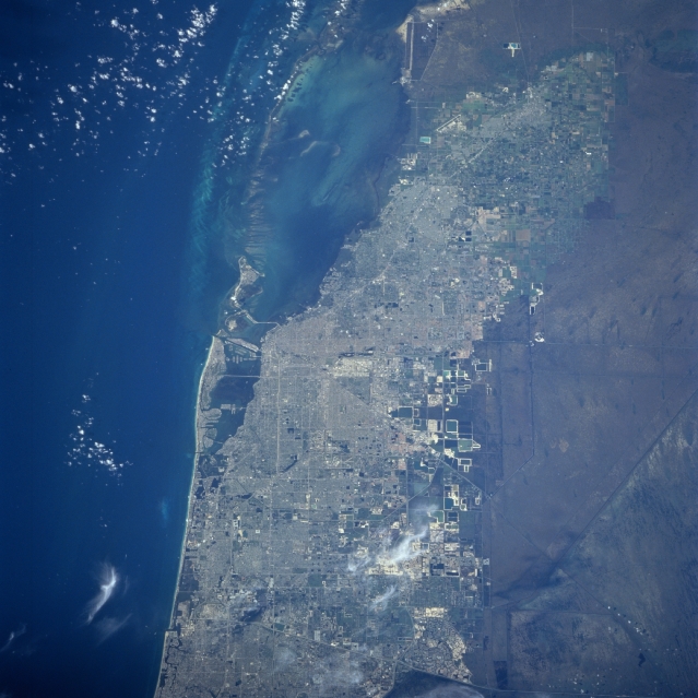 |
| STS094-753-055 Miami, Florida July 1997 The Greater Miami area can be seen in this spectacular south-looking view. Near the center of the image, the runways of Miami International Airport are discernible. East of the airport across Biscayne Bay, the city of Miami Beach is visible. Directly south of Miami Beach is the island of Key Biscayne. The far eastern portions of the Everglades are discernible to the west of Miami. The Miami area is one of the most popular and famous resort regions in the United States. Near the upper right portion of the image, the city of Homestead can be seen. In 1992 Hurricane Andrew, a category 4 hurricane, destroyed most homes and other structures while passing directly over Homestead. Hurricane Andrew is one of the most destructive hurricanes ever to make landfall in the United States. |
| Images: | All Available Images Low-Resolution 307k |
|
| Mission: | STS094 |
|
| Roll - Frame: | 753 - 55 |
|
| Geographical Name: | USA-FLORIDA |
|
| Features: | MIAMI |
|
| Center Lat x Lon: | 25.5N x 80W |
|
| Film Exposure: | N | N=Normal exposure, U=Under exposed, O=Over exposed, F=out of Focus |
| Percentage of Cloud Cover-CLDP: | 5 |
|
| Camera:: | HB |
|
| Camera Tilt: | 38 | LO=Low Oblique, HO=High Oblique, NV=Near Vertical |
| Camera Focal Length: | 250 |
|
| Nadir to Photo Center Direction: | S | The direction from the nadir to the center point, N=North, S=South, E=East, W=West |
| Stereo?: | Y | Y=Yes there is an adjacent picture of the same area, N=No there isn't |
| Orbit Number: | 173 |
|
| Date: | 19970712 | YYYYMMDD |
| Time: | 131038 | GMT HHMMSS |
| Nadir Lat: | 27.5N |
Latitude of suborbital point of spacecraft |
| Nadir Lon: | 80.4W |
Longitude of suborbital point of spacecraft |
| Sun Azimuth: | 80 | Clockwise angle in degrees from north to the sun measured at the nadir point |
| Space Craft Altitude: | 157 | nautical miles |
| Sun Elevation: | 32 | Angle in degrees between the horizon and the sun, measured at the nadir point |
| Land Views: | PLAIN |
|
| Water Views: | BAY, SWAMP, CHANNEL |
|
| Atmosphere Views: | |
|
| Man Made Views: | URBAN AREA, AIRPORT, HIGHWAY |
|
| City Views: | MIAMI |
|
Photo is not associated with any sequences | ||
| NASA Home Page |
JSC Home Page |
JSC Digital Image Collection |
Earth Science & Remote Sensing |
|
This service is provided by the International Space Station program and the JSC Earth Science & Remote Sensing Unit, ARES Division, Exploration Integration Science Directorate.

|