Geographic Region: PUERTO RICO
Feature: ARECIBO
|
Geographic Region: PUERTO RICO Feature: ARECIBO |
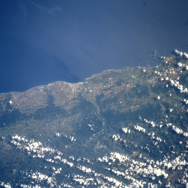 |
| STS094-748-002 Arecibo, Puerto Rico July 1997 Arecibo, a city along the northwest coast of Puerto Rico, can be identified as the highly reflective area near the center of the picture. This northwest coast region of Puerto Rico has a tropical wet climate. Rainfall amounts that exceed 60 inches (150cm) per year, coupled with the underlying limestone rocks, have created a unique "karst" topographic landscape. The dark swath of land inland but parallel to the coast shows the distribution of these hilly, densely vegetated, steep sided limestone erosional features. Daytime cloud buildups, which are a characteristic of the diurnal tropical precipitation pattern and are typical for the north facing slopes of the island, can be seen on this image. These clouds and the small scale of the image combine to obscure the location of the world's largest radio telescope (the Arecibo Observatory--National Astronomy and Ionosphere Center), which is located roughly 10 miles (16 km) south of Arecibo. Sections of Highway 2, the main highway that encircles most of the island commonwealth, are visible as a linear, light-colored feature, mainly west of Arecibo. |
| Images: | All Available Images Low-Resolution 368k |
|
| Mission: | STS094 |
|
| Roll - Frame: | 748 - 2 |
|
| Geographical Name: | PUERTO RICO |
|
| Features: | ARECIBO |
|
| Center Lat x Lon: | 18.5N x 66.5W |
|
| Film Exposure: | N | N=Normal exposure, U=Under exposed, O=Over exposed, F=out of Focus |
| Percentage of Cloud Cover-CLDP: | 20 |
|
| Camera:: | HB |
|
| Camera Tilt: | LO | LO=Low Oblique, HO=High Oblique, NV=Near Vertical |
| Camera Focal Length: | 250 |
|
| Nadir to Photo Center Direction: | The direction from the nadir to the center point, N=North, S=South, E=East, W=West |
|
| Stereo?: | Y | Y=Yes there is an adjacent picture of the same area, N=No there isn't |
| Orbit Number: | |
|
| Date: | 199707__ | YYYYMMDD |
| Time: | GMT HHMMSS |
|
| Nadir Lat: | N |
Latitude of suborbital point of spacecraft |
| Nadir Lon: | E |
Longitude of suborbital point of spacecraft |
| Sun Azimuth: | Clockwise angle in degrees from north to the sun measured at the nadir point |
|
| Space Craft Altitude: | nautical miles |
|
| Sun Elevation: | Angle in degrees between the horizon and the sun, measured at the nadir point |
|
| Land Views: | COAST, HILL |
|
| Water Views: | |
|
| Atmosphere Views: | |
|
| Man Made Views: | HIGHWAY |
|
| City Views: | ARECIBO |
|
Photo is not associated with any sequences | ||
| NASA Home Page |
JSC Home Page |
JSC Digital Image Collection |
Earth Science & Remote Sensing |
|
This service is provided by the International Space Station program and the JSC Earth Science & Remote Sensing Unit, ARES Division, Exploration Integration Science Directorate.

|