
Geographic Region: CUBA
Feature: BAY OF NIPE
|
Geographic Region: CUBA Feature: BAY OF NIPE |
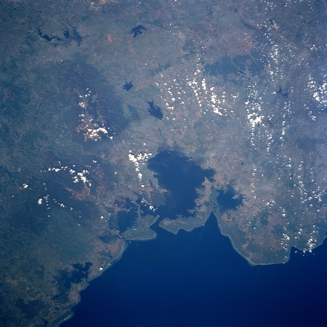 |
| STS094-743-007 Nipe Bay, Cuba July 1997 Nipe Bay (large, dark embayment) is located near the eastern end of the island and along the northeast coast of Cuba. According to published environmental reports this bay has a recent history of contamination from sewage and industrial waste runoff. Faint discolorations within the bay indicate that runoff seems to be entering the water from several different sources. The lighter terrain that is partially obscured by scattered clouds within the darker landscape south to southeast of the bay shows an extensive area of mining operations. This mining activity includes a wide range of alloy minerals--specifically manganese and nickel. The darker features are the western end of a forested mountain range, known as the Sierra de Micaro that is found along the extreme northeast coast of Cuba. Several sizable reservoirs (dark, irregular-shaped features) can be identified within the extensive agricultural lands west of the mountains. |
| Images: | All Available Images Low-Resolution 355k |
|
| Mission: | STS094 |
|
| Roll - Frame: | 743 - 7 |
|
| Geographical Name: | CUBA |
|
| Features: | BAY OF NIPE |
|
| Center Lat x Lon: | 20.5N x 76W |
|
| Film Exposure: | N | N=Normal exposure, U=Under exposed, O=Over exposed, F=out of Focus |
| Percentage of Cloud Cover-CLDP: | 5 |
|
| Camera:: | HB |
|
| Camera Tilt: | 43 | LO=Low Oblique, HO=High Oblique, NV=Near Vertical |
| Camera Focal Length: | 250 |
|
| Nadir to Photo Center Direction: | W | The direction from the nadir to the center point, N=North, S=South, E=East, W=West |
| Stereo?: | Y | Y=Yes there is an adjacent picture of the same area, N=No there isn't |
| Orbit Number: | 30 |
|
| Date: | 19970703 | YYYYMMDD |
| Time: | 133658 | GMT HHMMSS |
| Nadir Lat: | 21.1N |
Latitude of suborbital point of spacecraft |
| Nadir Lon: | 73.6W |
Longitude of suborbital point of spacecraft |
| Sun Azimuth: | 78 | Clockwise angle in degrees from north to the sun measured at the nadir point |
| Space Craft Altitude: | 160 | nautical miles |
| Sun Elevation: | 43 | Angle in degrees between the horizon and the sun, measured at the nadir point |
| Land Views: | MOUNTAIN, FOREST |
|
| Water Views: | BAY, RESERVOIR |
|
| Atmosphere Views: | |
|
| Man Made Views: | |
|
| City Views: | |
|
Photo is not associated with any sequences | ||
| NASA Home Page |
JSC Home Page |
JSC Digital Image Collection |
Earth Science & Remote Sensing |
|
This service is provided by the International Space Station program and the JSC Earth Science & Remote Sensing Unit, ARES Division, Exploration Integration Science Directorate.

|