Geographic Region: USA-HAWAII
Feature: MOLOKAI, LANAI
|
Geographic Region: USA-HAWAII Feature: MOLOKAI, LANAI |
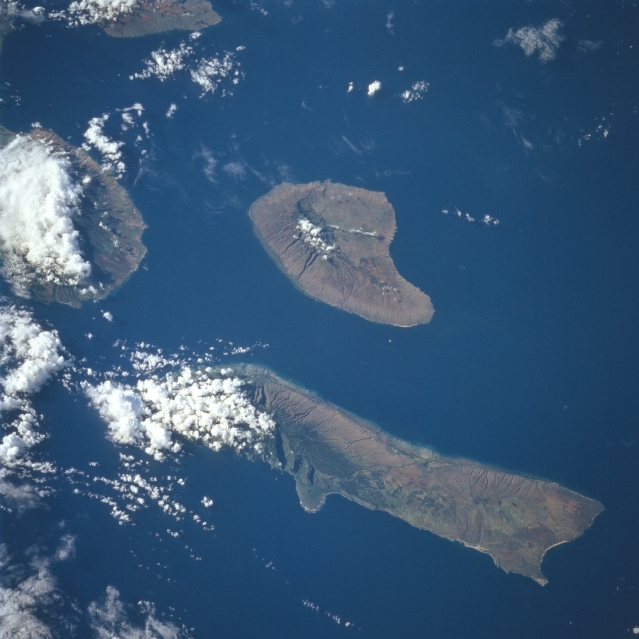 |
| STS094-735-067 Molokai, Lanai, Hawaiian Islands July 1997 The Hawaiian Islands of Molokai (long narrow island) and Lanai (near the center of the image) can be seen in this east-looking view. The island of Molokai is 40 miles (64 km) long and 7 miles (11 km) wide, and covers an area of 261 sq. miles (676 sq. km). The island, volcanic in nature, is generally mountainous. Kalaupapa Peninsula, located on the north side of Molokai near the left center of the image, is accessible only over a 2000 feet (610 meter) high mountain pass. It is on the Kalaupapa Peninsula that Father Damien, a Belgian Missionary, established a government leper colony in 1860. Today, along with increased tourism, Molokai has many cattle ranches and pineapple plantations. The island of Lanai covers an area of 141 sq. miles (365 sq. km). For many years, the island was used for sugarcane raising and cattle grazing. In 1922, the entire island of Lanai was purchased by a large pineapple company, which has developed the island into a pineapple-growing center. Cut by the top of the image, the western tip of the island of Maui can be seen. |
| Images: | All Available Images Low-Resolution 281k |
|
| Mission: | STS094 |
|
| Roll - Frame: | 735 - 67 |
|
| Geographical Name: | USA-HAWAII |
|
| Features: | MOLOKAI, LANAI |
|
| Center Lat x Lon: | 21.0N x 157W |
|
| Film Exposure: | N | N=Normal exposure, U=Under exposed, O=Over exposed, F=out of Focus |
| Percentage of Cloud Cover-CLDP: | 20 |
|
| Camera:: | HB |
|
| Camera Tilt: | 38 | LO=Low Oblique, HO=High Oblique, NV=Near Vertical |
| Camera Focal Length: | 100 |
|
| Nadir to Photo Center Direction: | S | The direction from the nadir to the center point, N=North, S=South, E=East, W=West |
| Stereo?: | Y | Y=Yes there is an adjacent picture of the same area, N=No there isn't |
| Orbit Number: | 65 |
|
| Date: | 19970705 | YYYYMMDD |
| Time: | 182051 | GMT HHMMSS |
| Nadir Lat: | 23.1N |
Latitude of suborbital point of spacecraft |
| Nadir Lon: | 156.8W |
Longitude of suborbital point of spacecraft |
| Sun Azimuth: | 77 | Clockwise angle in degrees from north to the sun measured at the nadir point |
| Space Craft Altitude: | 159 | nautical miles |
| Sun Elevation: | 33 | Angle in degrees between the horizon and the sun, measured at the nadir point |
| Land Views: | ISLAND, VOLCANO, COAST |
|
| Water Views: | |
|
| Atmosphere Views: | |
|
| Man Made Views: | |
|
| City Views: | |
|
Photo is not associated with any sequences | ||
| NASA Home Page |
JSC Home Page |
JSC Digital Image Collection |
Earth Science & Remote Sensing |
|
This service is provided by the International Space Station program and the JSC Earth Science & Remote Sensing Unit, ARES Division, Exploration Integration Science Directorate.

|