
Geographic Region: MEXICO
Feature: VERACRUZ
|
Geographic Region: MEXICO Feature: VERACRUZ |
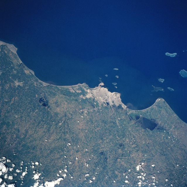 |
| STS094-731-017 Veracruz, Mexico July 1997 Located on the Gulf of Mexico, the city of Veracruz can be seen in this north-northeast-looking view. Veracruz stands on a low sandy plain surrounded by dunes and swamps, some of which have been reclaimed and are very fertile. Rivaling its northern neighbor Tampico as Mexico's main port, Veracruz is the commercial and industrial center of an important oil region, as well as a major tourist resort with beautiful scenery, fine beaches, and excellent accommodations. Besides oil refineries, Veracruz's industries include cigars, chocolate, liquors, tiles, and footwear. Lake Mandinga Grande is visible to the south (right) of the city. Scattered small islands and coral reefs are visible in the Gulf of Mexico to the east and southeast of the city. Scattered clouds cover the foothills of the Sierra Madre Oriental in the bottom left portion of the image. |
| Images: | All Available Images Low-Resolution 348k |
|
| Mission: | STS094 |
|
| Roll - Frame: | 731 - 17 |
|
| Geographical Name: | MEXICO |
|
| Features: | VERACRUZ |
|
| Center Lat x Lon: | 19.5N x 96W |
|
| Film Exposure: | N | N=Normal exposure, U=Under exposed, O=Over exposed, F=out of Focus |
| Percentage of Cloud Cover-CLDP: | 5 |
|
| Camera:: | HB |
|
| Camera Tilt: | 19 | LO=Low Oblique, HO=High Oblique, NV=Near Vertical |
| Camera Focal Length: | 100 |
|
| Nadir to Photo Center Direction: | E | The direction from the nadir to the center point, N=North, S=South, E=East, W=West |
| Stereo?: | Y | Y=Yes there is an adjacent picture of the same area, N=No there isn't |
| Orbit Number: | 66 |
|
| Date: | 19970705 | YYYYMMDD |
| Time: | 201132 | GMT HHMMSS |
| Nadir Lat: | 19.5N |
Latitude of suborbital point of spacecraft |
| Nadir Lon: | 96.9W |
Longitude of suborbital point of spacecraft |
| Sun Azimuth: | 283 | Clockwise angle in degrees from north to the sun measured at the nadir point |
| Space Craft Altitude: | 161 | nautical miles |
| Sun Elevation: | 67 | Angle in degrees between the horizon and the sun, measured at the nadir point |
| Land Views: | PLAIN, COAST, ISLAND |
|
| Water Views: | LAGOON, GULF |
|
| Atmosphere Views: | |
|
| Man Made Views: | URBAN AREA, AGRICULTURE |
|
| City Views: | VERACRUZ |
|
Photo is not associated with any sequences | ||
| NASA Home Page |
JSC Home Page |
JSC Digital Image Collection |
Earth Science & Remote Sensing |
|
This service is provided by the International Space Station program and the JSC Earth Science & Remote Sensing Unit, ARES Division, Exploration Integration Science Directorate.

|