
Geographic Region: HAITI
Feature: GULF OF LA GONAVE
|
Geographic Region: HAITI Feature: GULF OF LA GONAVE |
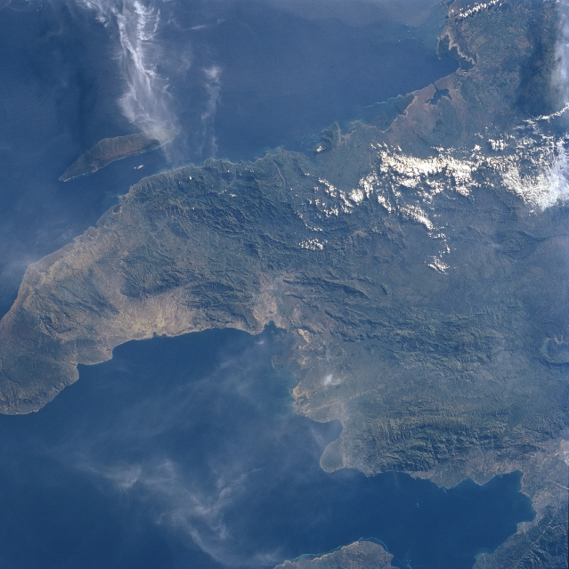 |
| STS094-728-024 Gulf of Gonave, Haiti July 1997 The northwest peninsula of Haiti and the Gulf of Gonave are visible in this northeast-looking view. The Gulf of Gonave is situated in the pincers of two mountainous peninsulas, and is considered one of the most beautiful in the world. Haiti, an Aboriginal Indian term, means "Land of Mountains". The mountains of the north, visible on this image, are made up of exposed limestone, which forms the terrain of the region. The porosity of the limestone prevents the formation of natural water reservoirs and facilitates run-off of rivulets, which denude the forests and erode the plains. Most of the country, including this northern portion, is semi-arid. Off the north coast of Haiti, the island of Tortuga or as referred to by the Haitans, the 'Island of Torture' is visible. The island is 25 miles (40 km) long and covers an area of 70 sq. miles (180 sq. km). Near the lower center of the image, a portion of the mountainous, barren Gonave Island is discernible. |
| Images: | All Available Images Low-Resolution 321k |
|
| Mission: | STS094 |
|
| Roll - Frame: | 728 - 24 |
|
| Geographical Name: | HAITI |
|
| Features: | GULF OF LA GONAVE |
|
| Center Lat x Lon: | 19.5N x 72.5W |
|
| Film Exposure: | N | N=Normal exposure, U=Under exposed, O=Over exposed, F=out of Focus |
| Percentage of Cloud Cover-CLDP: | 10 |
|
| Camera:: | HB |
|
| Camera Tilt: | 24 | LO=Low Oblique, HO=High Oblique, NV=Near Vertical |
| Camera Focal Length: | 100 |
|
| Nadir to Photo Center Direction: | E | The direction from the nadir to the center point, N=North, S=South, E=East, W=West |
| Stereo?: | Y | Y=Yes there is an adjacent picture of the same area, N=No there isn't |
| Orbit Number: | 61 |
|
| Date: | 19970705 | YYYYMMDD |
| Time: | 121702 | GMT HHMMSS |
| Nadir Lat: | 19.9N |
Latitude of suborbital point of spacecraft |
| Nadir Lon: | 73.6W |
Longitude of suborbital point of spacecraft |
| Sun Azimuth: | 73 | Clockwise angle in degrees from north to the sun measured at the nadir point |
| Space Craft Altitude: | 159 | nautical miles |
| Sun Elevation: | 25 | Angle in degrees between the horizon and the sun, measured at the nadir point |
| Land Views: | PENINSULA, MOUNTAIN, ISLAND, COAST |
|
| Water Views: | GULF |
|
| Atmosphere Views: | |
|
| Man Made Views: | |
|
| City Views: | |
|
Photo is not associated with any sequences | ||
| NASA Home Page |
JSC Home Page |
JSC Digital Image Collection |
Earth Science & Remote Sensing |
|
This service is provided by the International Space Station program and the JSC Earth Science & Remote Sensing Unit, ARES Division, Exploration Integration Science Directorate.

|