
Geographic Region: HONDURAS
Feature: GULF OF FONSECA
|
Geographic Region: HONDURAS Feature: GULF OF FONSECA |
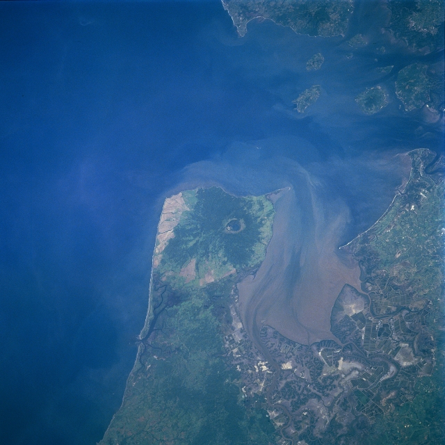 |
| STS094-723-083 Gulf of Fonseca, Nicaragua/Honduras July 1997 Three Central American countries--El Salvador (northwest), Honduras (east), and Nicaragua (south)--share the Gulf of Fonseca. Although the gulf is fairly large in size, measuring 70 miles (113 km) in northwest--southeast extent, its fragile ecosystem is being damaged at an alarming rate. The gulf's two major natural resources (mangrove forests and fisheries) are being depleted with serious consequences to the long-term effects of the marine environment, specifically the shrimp industry. Poorly marked international boundaries within the gulf have only exacerbated the economic problem. The angular patterns at the southeast end of the gulf are ponds used for the production of shrimp. The southeast end of the gulf also exhibits a large sediment plume in the water. The roughly oval-shaped feature near the north end of the Nicaraguan peninsula is the caldera of Cosiguina Volcano, a stratovolcano that last erupted in 1835. The summit of Cosiguina Volcano is 2818 feet (860 meters) above sea level and the caldera is approximately 1.2 miles (2 km) in diameter. The darker area that rings the caldera shows an area of dense, tropical vegetation. |
| Images: | All Available Images Low-Resolution 305k |
|
| Mission: | STS094 |
|
| Roll - Frame: | 723 - 83 |
|
| Geographical Name: | HONDURAS |
|
| Features: | GULF OF FONSECA |
|
| Center Lat x Lon: | 13.0N x 87.5W |
|
| Film Exposure: | N | N=Normal exposure, U=Under exposed, O=Over exposed, F=out of Focus |
| Percentage of Cloud Cover-CLDP: | 0 |
|
| Camera:: | HB |
|
| Camera Tilt: | 34 | LO=Low Oblique, HO=High Oblique, NV=Near Vertical |
| Camera Focal Length: | 100 |
|
| Nadir to Photo Center Direction: | W | The direction from the nadir to the center point, N=North, S=South, E=East, W=West |
| Stereo?: | Y | Y=Yes there is an adjacent picture of the same area, N=No there isn't |
| Orbit Number: | 144 |
|
| Date: | 19970710 | YYYYMMDD |
| Time: | 174254 | GMT HHMMSS |
| Nadir Lat: | 13.0N |
Latitude of suborbital point of spacecraft |
| Nadir Lon: | 85.7W |
Longitude of suborbital point of spacecraft |
| Sun Azimuth: | 7 | Clockwise angle in degrees from north to the sun measured at the nadir point |
| Space Craft Altitude: | 160 | nautical miles |
| Sun Elevation: | 81 | Angle in degrees between the horizon and the sun, measured at the nadir point |
| Land Views: | VOLCANO, CALDERA |
|
| Water Views: | GULF, SEDIMENT |
|
| Atmosphere Views: | |
|
| Man Made Views: | |
|
| City Views: | |
|
Photo is not associated with any sequences | ||
| NASA Home Page |
JSC Home Page |
JSC Digital Image Collection |
Earth Science & Remote Sensing |
|
This service is provided by the International Space Station program and the JSC Earth Science & Remote Sensing Unit, ARES Division, Exploration Integration Science Directorate.

|