
Geographic Region: CUBA
Feature: HAVANA
|
Geographic Region: CUBA Feature: HAVANA |
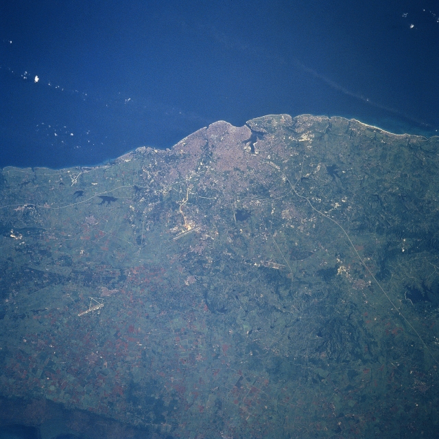 |
| STS094-720-004 Havana, Cuba July 1997 The capital city of Cuba, the largest island in the Caribbean, can be seen in this mostly north-looking view. Havana is located on the northwest coast of Cuba, 90 miles (145 km) south-southwest of Key West, Florida. One of the oldest cities in the Americas, Havana has one of the best natural port and harbor facilities in the Western Hemisphere. The older, historic part of Havana sets on the west side of the harbor, while the newer, industrialized portion extends to the west and south of the older, colonial part of the city. Industries include oil refineries, assembly plants, rum distilleries, sugar refineries, cigar factories, textile mills, and packing plants. Most of the people, who work in the Havana industries, live to the west and southwest of the City. The runways of the Jose Marti International Airport are visible 16 miles (25 km) to the southwest of Havana just past the urban areas and major transportation highways are visible leaving the central city. Nearly 100 homes were destroyed and many more damaged by Hurricane George as it passed to the north of the city in September of 1998. |
| Images: | All Available Images Low-Resolution 345k |
|
| Mission: | STS094 |
|
| Roll - Frame: | 720 - 4 |
|
| Geographical Name: | CUBA |
|
| Features: | HAVANA |
|
| Center Lat x Lon: | 22.0N x 82.5W |
|
| Film Exposure: | N | N=Normal exposure, U=Under exposed, O=Over exposed, F=out of Focus |
| Percentage of Cloud Cover-CLDP: | 0 |
|
| Camera:: | HB |
|
| Camera Tilt: | 29 | LO=Low Oblique, HO=High Oblique, NV=Near Vertical |
| Camera Focal Length: | 250 |
|
| Nadir to Photo Center Direction: | S | The direction from the nadir to the center point, N=North, S=South, E=East, W=West |
| Stereo?: | Y | Y=Yes there is an adjacent picture of the same area, N=No there isn't |
| Orbit Number: | 93 |
|
| Date: | 19970707 | YYYYMMDD |
| Time: | 123120 | GMT HHMMSS |
| Nadir Lat: | 23.5N |
Latitude of suborbital point of spacecraft |
| Nadir Lon: | 82.6W |
Longitude of suborbital point of spacecraft |
| Sun Azimuth: | 74 | Clockwise angle in degrees from north to the sun measured at the nadir point |
| Space Craft Altitude: | 159 | nautical miles |
| Sun Elevation: | 21 | Angle in degrees between the horizon and the sun, measured at the nadir point |
| Land Views: | COAST, PLAIN, HILL |
|
| Water Views: | |
|
| Atmosphere Views: | PLUME |
|
| Man Made Views: | URBAN AREA, AIRPORT |
|
| City Views: | HAVANA |
|
Photo is not associated with any sequences | ||
| NASA Home Page |
JSC Home Page |
JSC Digital Image Collection |
Earth Science & Remote Sensing |
|
This service is provided by the International Space Station program and the JSC Earth Science & Remote Sensing Unit, ARES Division, Exploration Integration Science Directorate.

|