Geographic Region: INDONESIA
Feature: SANGEANG ISLAND, SMOKE
|
Geographic Region: INDONESIA Feature: SANGEANG ISLAND, SMOKE |
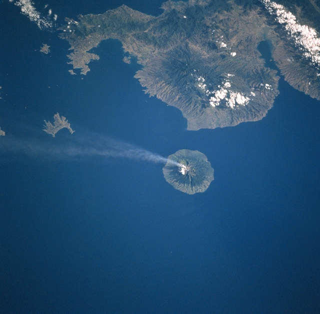 |
| STS094-718-007 Sangeang Island, Api Volcano, Indonesia July 1997 This southwest-looking view shows the Indonesian island of Sangeang, and a smoke cloud blowing in a southeasterly direction from Api Volcano. Sangeang is an 8-mile (13 km) wide island that is located off the northeast coast of Sumbawa Island (top of image). Api is one of the most active volcanoes in the Lesser Sunda Islands. The volcano is made up of two volcanic cones, the highest being Mount Dori at 6393 feet (1949 meters) above sea level. Intermittent historical eruptions of Api Volcano have been recorded since 1512, but most occurred during the 20th Century. To the left (southeast) of Sangeang Island is Banta Island, the remains of a former volcano. Though partially cloud covered, the Sape Strait is discernible in the upper left corner of the image. Bima Bay on the island of Sumbawa is visible in the upper right portion of the image. |
| Images: | All Available Images Low-Resolution 305k |
|
| Mission: | STS094 |
|
| Roll - Frame: | 718 - 7 |
|
| Geographical Name: | INDONESIA |
|
| Features: | SANGEANG ISLAND, SMOKE |
|
| Center Lat x Lon: | 8S x 119.0E |
|
| Film Exposure: | N | N=Normal exposure, U=Under exposed, O=Over exposed, F=out of Focus |
| Percentage of Cloud Cover-CLDP: | 5 |
|
| Camera:: | HB |
|
| Camera Tilt: | 37 | LO=Low Oblique, HO=High Oblique, NV=Near Vertical |
| Camera Focal Length: | 100 |
|
| Nadir to Photo Center Direction: | SW | The direction from the nadir to the center point, N=North, S=South, E=East, W=West |
| Stereo?: | Y | Y=Yes there is an adjacent picture of the same area, N=No there isn't |
| Orbit Number: | 121 |
|
| Date: | 19970709 | YYYYMMDD |
| Time: | 071533 | GMT HHMMSS |
| Nadir Lat: | 6.5S |
Latitude of suborbital point of spacecraft |
| Nadir Lon: | 120.4E |
Longitude of suborbital point of spacecraft |
| Sun Azimuth: | 303 | Clockwise angle in degrees from north to the sun measured at the nadir point |
| Space Craft Altitude: | 163 | nautical miles |
| Sun Elevation: | 35 | Angle in degrees between the horizon and the sun, measured at the nadir point |
| Land Views: | ISLAND, VOLCANO, MOUNTAIN |
|
| Water Views: | SEA, STRAIT, BAY |
|
| Atmosphere Views: | PLUME |
|
| Man Made Views: | |
|
| City Views: | |
|
Photo is not associated with any sequences | ||
| NASA Home Page |
JSC Home Page |
JSC Digital Image Collection |
Earth Science & Remote Sensing |
|
This service is provided by the International Space Station program and the JSC Earth Science & Remote Sensing Unit, ARES Division, Exploration Integration Science Directorate.

|