Geographic Region: INDIA
Feature: SAMBHAR SALT LAKE
|
Geographic Region: INDIA Feature: SAMBHAR SALT LAKE |
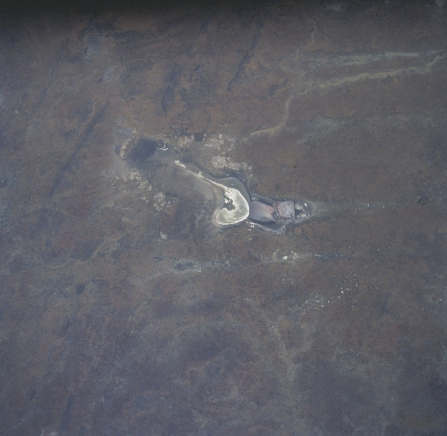 |
| STS094-712-021 Sambhar Salt Lake, India July 1997 The elongated Sambhar Salt Lake, situated in a depression of the low, northeast-southwest trending Aravalli Mountains (a few faint ridgelines are visible in the upper left quadrant), is recognizable at the center of the image. The general region is on the eastern fringe of the Great Indian (Thar) Desert and the western edge of the semiarid climate of northwest India. The lake is just west of the Indian city of Jaipur. This ephemeral salt lake measures approximately 20 miles (32 km) in an east-west direction. Several distinct sections of the lake can be identified. For example a couple of areas of standing water are visible (uniform, tan-looking) as well as the highly mineralized, dry surface (whitish-looking area). The lake is used intensively for the commercial mining of salt. Water levels in the lake fluctuates dramatically, depending on how much precipitation the region receives in a given year. |
| Images: | All Available Images Low-Resolution 286k |
|
| Mission: | STS094 |
|
| Roll - Frame: | 712 - 21 |
|
| Geographical Name: | INDIA |
|
| Features: | SAMBHAR SALT LAKE |
|
| Center Lat x Lon: | 27.0N x 75.0E |
|
| Film Exposure: | N | N=Normal exposure, U=Under exposed, O=Over exposed, F=out of Focus |
| Percentage of Cloud Cover-CLDP: | 0 |
|
| Camera:: | HB |
|
| Camera Tilt: | LO | LO=Low Oblique, HO=High Oblique, NV=Near Vertical |
| Camera Focal Length: | 100 |
|
| Nadir to Photo Center Direction: | The direction from the nadir to the center point, N=North, S=South, E=East, W=West |
|
| Stereo?: | Y | Y=Yes there is an adjacent picture of the same area, N=No there isn't |
| Orbit Number: | |
|
| Date: | 199707__ | YYYYMMDD |
| Time: | GMT HHMMSS |
|
| Nadir Lat: | N |
Latitude of suborbital point of spacecraft |
| Nadir Lon: | E |
Longitude of suborbital point of spacecraft |
| Sun Azimuth: | Clockwise angle in degrees from north to the sun measured at the nadir point |
|
| Space Craft Altitude: | nautical miles |
|
| Sun Elevation: | Angle in degrees between the horizon and the sun, measured at the nadir point |
|
| Land Views: | DESERT |
|
| Water Views: | PLAYA |
|
| Atmosphere Views: | |
|
| Man Made Views: | MINING |
|
| City Views: | |
|
Photo is not associated with any sequences | ||
| NASA Home Page |
JSC Home Page |
JSC Digital Image Collection |
Earth Science & Remote Sensing |
|
This service is provided by the International Space Station program and the JSC Earth Science & Remote Sensing Unit, ARES Division, Exploration Integration Science Directorate.

|