Geographic Region: BRAZIL
Feature: RIO TOCATINS
|
Geographic Region: BRAZIL Feature: RIO TOCATINS |
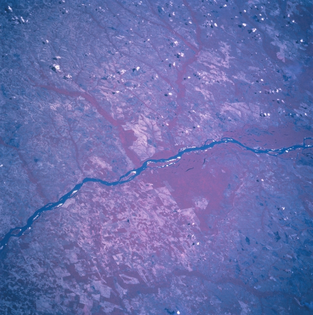 |
| STS094-703-099 Rio Araguaia, Brazil July 1997 The northeasterly flowing Rio Araguaia (dark, linear feature), one of many rivers that drain the Amazon Basin in east central Brazil, is easily traced laterally across this color infrared image. The color infrared picture (green vegetation is shown as various reddish hues) not only shows the main channel of the river and numerous sand bars (white surfaces within the river), but forested tributary streams are also visible as uniform looking reddish swaths that connect to the main channel of the Rio Araguaia. Two low-lying, densely vegetated swampy areas with numerous small lakes (dark features) can be identified near the center of the image and also near the southwest edge of the scene. The lighter looking terrain, some with angular-looking, large field patterns, are areas that have been cleared for farming or cattle ranching. The Brazalian state of Para is west of the river and Tocantins state is east of the river. |
| Images: | All Available Images Low-Resolution 343k |
|
| Mission: | STS094 |
|
| Roll - Frame: | 703 - 99 |
|
| Geographical Name: | BRAZIL |
|
| Features: | RIO TOCATINS |
|
| Center Lat x Lon: | 7.5S x 47.5W |
|
| Film Exposure: | N | N=Normal exposure, U=Under exposed, O=Over exposed, F=out of Focus |
| Percentage of Cloud Cover-CLDP: | 5 |
|
| Camera:: | HB |
|
| Camera Tilt: | 42 | LO=Low Oblique, HO=High Oblique, NV=Near Vertical |
| Camera Focal Length: | 250 |
|
| Nadir to Photo Center Direction: | SE | The direction from the nadir to the center point, N=North, S=South, E=East, W=West |
| Stereo?: | Y | Y=Yes there is an adjacent picture of the same area, N=No there isn't |
| Orbit Number: | 175 |
|
| Date: | 19970712 | YYYYMMDD |
| Time: | 163244 | GMT HHMMSS |
| Nadir Lat: | 5.7S |
Latitude of suborbital point of spacecraft |
| Nadir Lon: | 49.1W |
Longitude of suborbital point of spacecraft |
| Sun Azimuth: | 328 | Clockwise angle in degrees from north to the sun measured at the nadir point |
| Space Craft Altitude: | 161 | nautical miles |
| Sun Elevation: | 57 | Angle in degrees between the horizon and the sun, measured at the nadir point |
| Land Views: | FOREST |
|
| Water Views: | RIVER |
|
| Atmosphere Views: | |
|
| Man Made Views: | AGRICULTURE |
|
| City Views: | |
|
Photo is not associated with any sequences | ||
| NASA Home Page |
JSC Home Page |
JSC Digital Image Collection |
Earth Science & Remote Sensing |
|
This service is provided by the International Space Station program and the JSC Earth Science & Remote Sensing Unit, ARES Division, Exploration Integration Science Directorate.

|