Geographic Region: BRAZIL
Feature: RIO TAPAJOS, RIO CREPORI
|
Geographic Region: BRAZIL Feature: RIO TAPAJOS, RIO CREPORI |
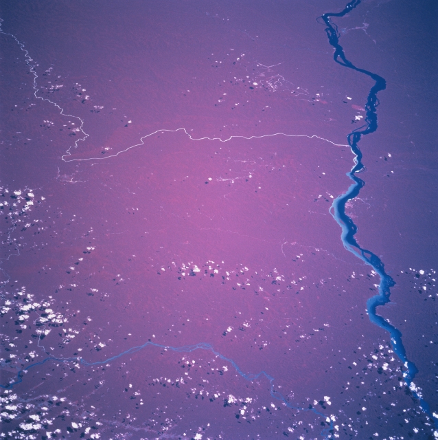 |
| STS094-703-090 Rio Tapajos, Para State, Brazil July 1997 Except for scattered clouds and a few rivers in this region of the Amazon Basin, this color infrared image (green vegetation is shown as a reddish color) shows virtually an unbroken canopy of the Amazon rainforest in southwestern Para state. The thin, light colored (muddy) Rio Crepori merges with the much broader, northeasterly flowing Rio Tapajos (dark linear feature). Note that the sediment-laden water from the Rio Crepori does not mix with the water of the Rio Tapajos but instead hugs the eastern shore of the Rio Tapajos for many miles downstream. The Rio Jamanxim is also visible near the bottom of the photograph as it heads north to eventually flow into the Rio Tapajos (not visible in this image). A few small areas (lighter colored scars, top right and bottom center) can be discerned where human development is just beginning to occur in this rainforest area. |
| Images: | All Available Images Low-Resolution 307k |
|
| Mission: | STS094 |
|
| Roll - Frame: | 703 - 90 |
|
| Geographical Name: | BRAZIL |
|
| Features: | RIO TAPAJOS, RIO CREPORI |
|
| Center Lat x Lon: | 6.5S x 57W |
|
| Film Exposure: | N | N=Normal exposure, U=Under exposed, O=Over exposed, F=out of Focus |
| Percentage of Cloud Cover-CLDP: | 10 |
|
| Camera:: | HB |
|
| Camera Tilt: | LO | LO=Low Oblique, HO=High Oblique, NV=Near Vertical |
| Camera Focal Length: | 250 |
|
| Nadir to Photo Center Direction: | SW | The direction from the nadir to the center point, N=North, S=South, E=East, W=West |
| Stereo?: | Y | Y=Yes there is an adjacent picture of the same area, N=No there isn't |
| Orbit Number: | 175 |
|
| Date: | 19970712 | YYYYMMDD |
| Time: | 163116 | GMT HHMMSS |
| Nadir Lat: | 3S |
Latitude of suborbital point of spacecraft |
| Nadir Lon: | 53.9W |
Longitude of suborbital point of spacecraft |
| Sun Azimuth: | 334 | Clockwise angle in degrees from north to the sun measured at the nadir point |
| Space Craft Altitude: | 161 | nautical miles |
| Sun Elevation: | 62 | Angle in degrees between the horizon and the sun, measured at the nadir point |
| Land Views: | FOREST |
|
| Water Views: | RIVER |
|
| Atmosphere Views: | |
|
| Man Made Views: | |
|
| City Views: | |
|
Photo is not associated with any sequences | ||
| NASA Home Page |
JSC Home Page |
JSC Digital Image Collection |
Earth Science & Remote Sensing |
|
This service is provided by the International Space Station program and the JSC Earth Science & Remote Sensing Unit, ARES Division, Exploration Integration Science Directorate.

|