
Geographic Region: USA-NEW YORK
Feature: PAN-LAKE ONTARIO, SMOG, SUNGLINT
|
Geographic Region: USA-NEW YORK Feature: PAN-LAKE ONTARIO, SMOG, SUNGLINT |
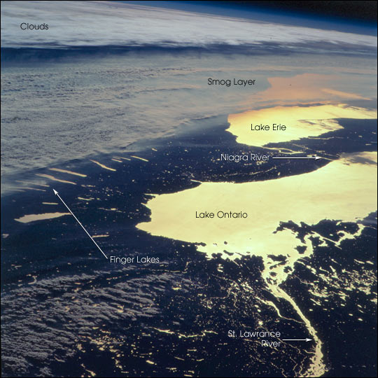 |
| The STS-92 Space Shuttle astronauts photographed upstate New York at sunset on October 21, 2000. Water bodies (Lake Ontario, Lake Erie, the Finger Lakes, the St. Lawrence and Niagara Rivers) are highlighted by sunglint (sun reflecting off the water surface), making for a dramatic and unusual regional view. The photograph was taken looking toward the southwest from southern Canada, and captures a regional smog layer extending across central New York, western Lake Erie and Ohio, and further west. The layer of atmospheric pollution layer is capped by an atmospheric inversion, which is marked by the layer of clouds at the top of the photograph. The astronauts were able to document this smog event from a variety of vantage points as they orbited over the northeastern U.S. and southern Canada. |
| Images: | All Available Images Low-Resolution 75k |
|
| Mission: | STS092 |
|
| Roll - Frame: | 713 - 32 |
|
| Geographical Name: | USA-NEW YORK |
|
| Features: | PAN-LAKE ONTARIO, SMOG, SUNGLINT |
|
| Center Lat x Lon: | 43.5N x 77W |
|
| Film Exposure: | N=Normal exposure, U=Under exposed, O=Over exposed, F=out of Focus |
|
| Percentage of Cloud Cover-CLDP: | 50 |
|
| Camera:: | HB |
|
| Camera Tilt: | HO | LO=Low Oblique, HO=High Oblique, NV=Near Vertical |
| Camera Focal Length: | 250 |
|
| Nadir to Photo Center Direction: | W | The direction from the nadir to the center point, N=North, S=South, E=East, W=West |
| Stereo?: | Y=Yes there is an adjacent picture of the same area, N=No there isn't |
|
| Orbit Number: | 156 |
|
| Date: | 20001021 | YYYYMMDD |
| Time: | 204237 | GMT HHMMSS |
| Nadir Lat: | 48.1N |
Latitude of suborbital point of spacecraft |
| Nadir Lon: | 64.6W |
Longitude of suborbital point of spacecraft |
| Sun Azimuth: | 248 | Clockwise angle in degrees from north to the sun measured at the nadir point |
| Space Craft Altitude: | 202 | nautical miles |
| Sun Elevation: | 5 | Angle in degrees between the horizon and the sun, measured at the nadir point |
| Land Views: | |
|
| Water Views: | LAKE, SUNGLINT |
|
| Atmosphere Views: | SMOG |
|
| Man Made Views: | POLLUTION |
|
| City Views: | |
|
Photo is not associated with any sequences | ||
| NASA Home Page |
JSC Home Page |
JSC Digital Image Collection |
Earth Science & Remote Sensing |
|
This service is provided by the International Space Station program and the JSC Earth Science & Remote Sensing Unit, ARES Division, Exploration Integration Science Directorate.

|