
Geographic Region: USA-NORTH CAROLINA
Feature: PAMLICO SOUND, SMOKE
|
Geographic Region: USA-NORTH CAROLINA Feature: PAMLICO SOUND, SMOKE |
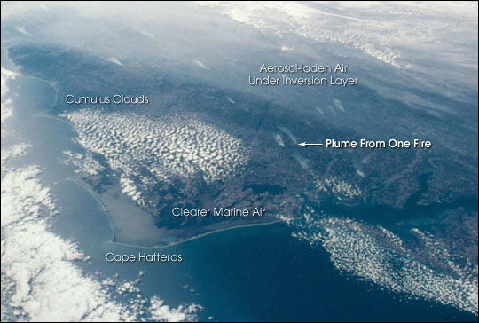 |
| This photograph taken from the Space Shuttle Discovery was taken at a slightly oblique look angle to better view air pollution and other atmospheric features. The photograph was taken with the Shuttle in a position over the Atlantic Ocean looking back toward the North Carolina and Virginia coast. The astronauts used a 35 mm camera and standard color film. The section of coast shown stretches from the Delmarva Peninsula on the right to beyond Charleston, South Carolina on the left. On October 23, 2000, high pressure centered over the northeastern U.S. had created a capping inversion for aerosols. Forest fire smoke and industrial air pollution accumulated under the inversion. The inversion pattern is stronger inland, and the aerosols are being banked against the Piedmont. Relatively clearer air is flowing from the ocean over the Carolina coastal plain. Small smoke plumes from individual fires can also be seen on the ground stretching from central Virginia to Raleigh, NC. |
| Images: | All Available Images Low-Resolution 48k |
|
| Mission: | STS092 |
|
| Roll - Frame: | 324 - 26 |
|
| Geographical Name: | USA-NORTH CAROLINA |
|
| Features: | PAMLICO SOUND, SMOKE |
|
| Center Lat x Lon: | 36.5N x 76.5W |
|
| Film Exposure: | N=Normal exposure, U=Under exposed, O=Over exposed, F=out of Focus |
|
| Percentage of Cloud Cover-CLDP: | 25 |
|
| Camera:: | NK |
|
| Camera Tilt: | HO | LO=Low Oblique, HO=High Oblique, NV=Near Vertical |
| Camera Focal Length: | |
|
| Nadir to Photo Center Direction: | W | The direction from the nadir to the center point, N=North, S=South, E=East, W=West |
| Stereo?: | Y=Yes there is an adjacent picture of the same area, N=No there isn't |
|
| Orbit Number: | 186 |
|
| Date: | 20001023 | YYYYMMDD |
| Time: | 184241 | GMT HHMMSS |
| Nadir Lat: | 37.2N |
Latitude of suborbital point of spacecraft |
| Nadir Lon: | 71W |
Longitude of suborbital point of spacecraft |
| Sun Azimuth: | 220 | Clockwise angle in degrees from north to the sun measured at the nadir point |
| Space Craft Altitude: | 202 | nautical miles |
| Sun Elevation: | 32 | Angle in degrees between the horizon and the sun, measured at the nadir point |
| Land Views: | COAST, FOREST, PENINSULA, PLAIN |
|
| Water Views: | OCEAN |
|
| Atmosphere Views: | SMOKE, PLUME |
|
| Man Made Views: | POLLUTION |
|
| City Views: | CHARLESTON, RALEIGH |
|
Photo is not associated with any sequences | ||
| NASA Home Page |
JSC Home Page |
JSC Digital Image Collection |
Earth Science & Remote Sensing |
|
This service is provided by the International Space Station program and the JSC Earth Science & Remote Sensing Unit, ARES Division, Exploration Integration Science Directorate.

|