
Geographic Region: BAHAMAS
Feature: FREEPORT,GRAND BAHAMA I.
|
Geographic Region: BAHAMAS Feature: FREEPORT,GRAND BAHAMA I. |
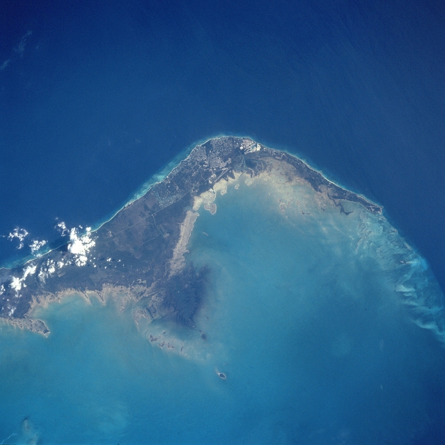 |
| STS091-731-032 Grand Bahama Island, Freeport and Lucaya, Bahamas June 1998 The small cities of Freeport and Lucaya, on the southwest portion of Grand Bahama Island (slightly above the center of the view), can be seen in this southwest-looking view. Freeport and Lucaya are the Bahamas second largest metropolitan area. Nearly 50 years ago, neither city even existed. The Freeport and Lucaya region is a free trade zone area. Besides numerous tourist resorts and recreational areas, Freeport and Lucaya's other activities include oil refining, cement production, distilling of liquor, and making of pharmaceutical products. As with the other islands of the Bahamas, Grand Bahama is composed largely of calcareous materials derived from marine organisms. A karst landscape covers many of the higher elevations on the island. Grand Bahama Island is 96 miles (154 km) long and 17 miles (27 km) at its widest point. The darker blue, deep waters of the Atlantic Ocean are visible in the upper portion of the view. The lighter blue, shallow waters covering the Bahama Shelf are discernible in the bottom portion of the view. |
| Images: | All Available Images Low-Resolution 277k |
|
| Mission: | STS091 |
|
| Roll - Frame: | 731 - 32 |
|
| Geographical Name: | BAHAMAS |
|
| Features: | FREEPORT,GRAND BAHAMA I. |
|
| Center Lat x Lon: | 26.5N x 78.5W |
|
| Film Exposure: | N | N=Normal exposure, U=Under exposed, O=Over exposed, F=out of Focus |
| Percentage of Cloud Cover-CLDP: | 5 |
|
| Camera:: | HB |
|
| Camera Tilt: | 16 | LO=Low Oblique, HO=High Oblique, NV=Near Vertical |
| Camera Focal Length: | 250 |
|
| Nadir to Photo Center Direction: | NW | The direction from the nadir to the center point, N=North, S=South, E=East, W=West |
| Stereo?: | Y | Y=Yes there is an adjacent picture of the same area, N=No there isn't |
| Orbit Number: | 78 |
|
| Date: | 19980607 | YYYYMMDD |
| Time: | 195254 | GMT HHMMSS |
| Nadir Lat: | 25.8N |
Latitude of suborbital point of spacecraft |
| Nadir Lon: | 77.9W |
Longitude of suborbital point of spacecraft |
| Sun Azimuth: | 274 | Clockwise angle in degrees from north to the sun measured at the nadir point |
| Space Craft Altitude: | 198 | nautical miles |
| Sun Elevation: | 53 | Angle in degrees between the horizon and the sun, measured at the nadir point |
| Land Views: | ISLAND, COAST |
|
| Water Views: | OCEAN |
|
| Atmosphere Views: | |
|
| Man Made Views: | URBAN AREA, AIRPORT |
|
| City Views: | FREEPORT |
|
Photo is not associated with any sequences | ||
| NASA Home Page |
JSC Home Page |
JSC Digital Image Collection |
Earth Science & Remote Sensing |
|
This service is provided by the International Space Station program and the JSC Earth Science & Remote Sensing Unit, ARES Division, Exploration Integration Science Directorate.

|