
Geographic Region: BAHAMAS
Feature: NORTH AND SOUTH BIMINI
|
Geographic Region: BAHAMAS Feature: NORTH AND SOUTH BIMINI |
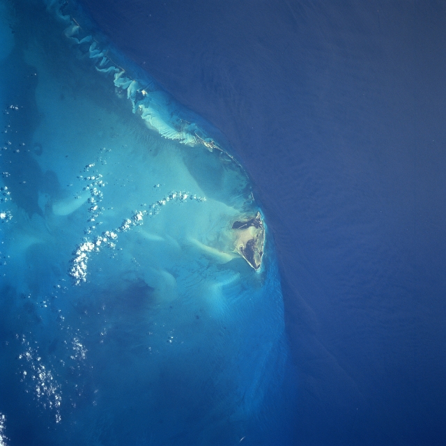 |
| STS091-731-28 Bimini Island, Bahama Islands June 1998 The westernmost and closest to the United States mainland, the island of Bimini can be seen in this south-southwest-looking view. The two small islands that make up Bimini cover a total area of 9 sq. miles (23 sq. km). The waters surrounding Bimini are known for their excellent fishing. Bimini resembles an idyllic South Pacific atoll with a blue lagoon nearly enclosed by the two small islands. The island was named for the mythical island of Bimini, supposed site of the "Fountain of Youth", the quest for which led to the discovery of Florida in 1513 by Ponce De Leon. |
| Images: | All Available Images Low-Resolution 258k |
|
| Mission: | STS091 |
|
| Roll - Frame: | 731 - 28 |
|
| Geographical Name: | BAHAMAS |
|
| Features: | NORTH AND SOUTH BIMINI |
|
| Center Lat x Lon: | 25.5N x 79.5W |
|
| Film Exposure: | N | N=Normal exposure, U=Under exposed, O=Over exposed, F=out of Focus |
| Percentage of Cloud Cover-CLDP: | 5 |
|
| Camera:: | HB |
|
| Camera Tilt: | 19 | LO=Low Oblique, HO=High Oblique, NV=Near Vertical |
| Camera Focal Length: | 250 |
|
| Nadir to Photo Center Direction: | W | The direction from the nadir to the center point, N=North, S=South, E=East, W=West |
| Stereo?: | Y | Y=Yes there is an adjacent picture of the same area, N=No there isn't |
| Orbit Number: | 78 |
|
| Date: | 19980607 | YYYYMMDD |
| Time: | 195242 | GMT HHMMSS |
| Nadir Lat: | 25.2N |
Latitude of suborbital point of spacecraft |
| Nadir Lon: | 78.4W |
Longitude of suborbital point of spacecraft |
| Sun Azimuth: | 275 | Clockwise angle in degrees from north to the sun measured at the nadir point |
| Space Craft Altitude: | 198 | nautical miles |
| Sun Elevation: | 53 | Angle in degrees between the horizon and the sun, measured at the nadir point |
| Land Views: | ISLAND |
|
| Water Views: | LAGOON, OCEAN |
|
| Atmosphere Views: | |
|
| Man Made Views: | |
|
| City Views: | |
|
Photo is not associated with any sequences | ||
| NASA Home Page |
JSC Home Page |
JSC Digital Image Collection |
Earth Science & Remote Sensing |
|
This service is provided by the International Space Station program and the JSC Earth Science & Remote Sensing Unit, ARES Division, Exploration Integration Science Directorate.

|