
Geographic Region: BRAZIL
Feature: RIO GRANDE, L. DOS PATOS
|
Geographic Region: BRAZIL Feature: RIO GRANDE, L. DOS PATOS |
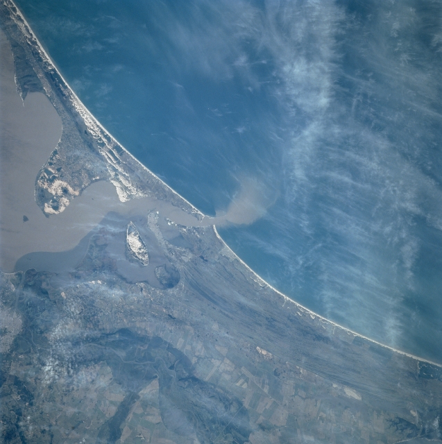 |
| STS091-729-043 Southern Dos Patos Lagoon, Brazil June 1998 The sediment-laden Rio Grande empties into the Dos Patos Lagoon and eventually into the Atlantic Ocean. The Dos Patos (center of image) is a shallow tidal lagoon separated from the Atlantic Ocean by a wide sandbar or sandy peninsula. The peninsula has an average width of 15 miles (24 km). Barely discernible and entering the scene from the bottom center (southwest) is a canal or river that flows generally northward from the Mirin Lagoon (not on image) to the city of Pelotas (midway between the left center and bottom left) and empties into the southern portion of the Dos Patos Lagoon. The Mirin Lagoon's darker waters can be seen mixing with the muddy waters of the Dos Patos Lagoon as they both head in the direction of the Atlantic Ocean. The waters in these lagoons has been degraded by increased industrial and domestic effluents during last three decades. Efforts are underway by the government of Brazil to reduce these effluents. |
| Images: | All Available Images Low-Resolution 289k |
|
| Mission: | STS091 |
|
| Roll - Frame: | 729 - 43 |
|
| Geographical Name: | BRAZIL |
|
| Features: | RIO GRANDE, L. DOS PATOS |
|
| Center Lat x Lon: | 32S x 52W |
|
| Film Exposure: | N | N=Normal exposure, U=Under exposed, O=Over exposed, F=out of Focus |
| Percentage of Cloud Cover-CLDP: | 10 |
|
| Camera:: | HB |
|
| Camera Tilt: | 28 | LO=Low Oblique, HO=High Oblique, NV=Near Vertical |
| Camera Focal Length: | 250 |
|
| Nadir to Photo Center Direction: | SE | The direction from the nadir to the center point, N=North, S=South, E=East, W=West |
| Stereo?: | Y | Y=Yes there is an adjacent picture of the same area, N=No there isn't |
| Orbit Number: | 74 |
|
| Date: | 19980607 | YYYYMMDD |
| Time: | 145802 | GMT HHMMSS |
| Nadir Lat: | 31.1S |
Latitude of suborbital point of spacecraft |
| Nadir Lon: | 53.6W |
Longitude of suborbital point of spacecraft |
| Sun Azimuth: | 10 | Clockwise angle in degrees from north to the sun measured at the nadir point |
| Space Craft Altitude: | 205 | nautical miles |
| Sun Elevation: | 36 | Angle in degrees between the horizon and the sun, measured at the nadir point |
| Land Views: | COAST, DUNE |
|
| Water Views: | LAGOON, RIVER, SEDIMENT |
|
| Atmosphere Views: | |
|
| Man Made Views: | AGRICULTURE, URBAN AREA |
|
| City Views: | |
|
Photo is not associated with any sequences | ||
| NASA Home Page |
JSC Home Page |
JSC Digital Image Collection |
Earth Science & Remote Sensing |
|
This service is provided by the International Space Station program and the JSC Earth Science & Remote Sensing Unit, ARES Division, Exploration Integration Science Directorate.

|