Geographic Region: CHILE
Feature: CAMPANA ISLAND, PRAT I.
|
Geographic Region: CHILE Feature: CAMPANA ISLAND, PRAT I. |
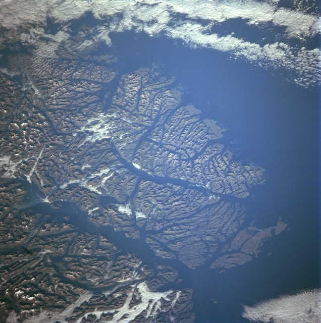 |
| STS091-729-004 Guayaneco Archipelago, Chile June 1998 The islands of the Guayaneco Archipelago can be seen in this southwest-looking view. The Guayaneco Archipelago was heavily glaciated during the most recent ice age. These glaciers dissected these mountain islands into a series of deep river valleys and glacial troughs. Today these glacial troughs are deep channels and fjords. The islands of the Guayaneco Archipelago comprise a series of elongated islands and deep bays that are the traces of a drowned coastal range. A number of deep channels are visible traversing generally north to south through the islands. These include the Messier Channel in the lower left portion of the image, and the Fallos Channel near the center of the image. The Pacific Ocean covers most of the upper center and upper right portion of the image. Forests cover the lower slopes of the mountains throughout the many islands. Human settlement on these islands is scarce. |
| Images: | All Available Images Low-Resolution 351k |
|
| Mission: | STS091 |
|
| Roll - Frame: | 729 - 4 |
|
| Geographical Name: | CHILE |
|
| Features: | CAMPANA ISLAND, PRAT I. |
|
| Center Lat x Lon: | 48S x 75W |
|
| Film Exposure: | N | N=Normal exposure, U=Under exposed, O=Over exposed, F=out of Focus |
| Percentage of Cloud Cover-CLDP: | 5 |
|
| Camera:: | HB |
|
| Camera Tilt: | 52 | LO=Low Oblique, HO=High Oblique, NV=Near Vertical |
| Camera Focal Length: | 250 |
|
| Nadir to Photo Center Direction: | S | The direction from the nadir to the center point, N=North, S=South, E=East, W=West |
| Stereo?: | N | Y=Yes there is an adjacent picture of the same area, N=No there isn't |
| Orbit Number: | 74 |
|
| Date: | 19980607 | YYYYMMDD |
| Time: | 145240 | GMT HHMMSS |
| Nadir Lat: | 44S |
Latitude of suborbital point of spacecraft |
| Nadir Lon: | 73.2W |
Longitude of suborbital point of spacecraft |
| Sun Azimuth: | 29 | Clockwise angle in degrees from north to the sun measured at the nadir point |
| Space Craft Altitude: | 206 | nautical miles |
| Sun Elevation: | 18 | Angle in degrees between the horizon and the sun, measured at the nadir point |
| Land Views: | MOUNTAIN, ISLAND, GLACIER |
|
| Water Views: | CHANNEL, OCEAN, GULF |
|
| Atmosphere Views: | |
|
| Man Made Views: | |
|
| City Views: | |
|
Photo is not associated with any sequences | ||
| NASA Home Page |
JSC Home Page |
JSC Digital Image Collection |
Earth Science & Remote Sensing |
|
This service is provided by the International Space Station program and the JSC Earth Science & Remote Sensing Unit, ARES Division, Exploration Integration Science Directorate.

|