
Geographic Region: IRAN
Feature: RASHT,COAST,SEND R. DELTA
|
Geographic Region: IRAN Feature: RASHT,COAST,SEND R. DELTA |
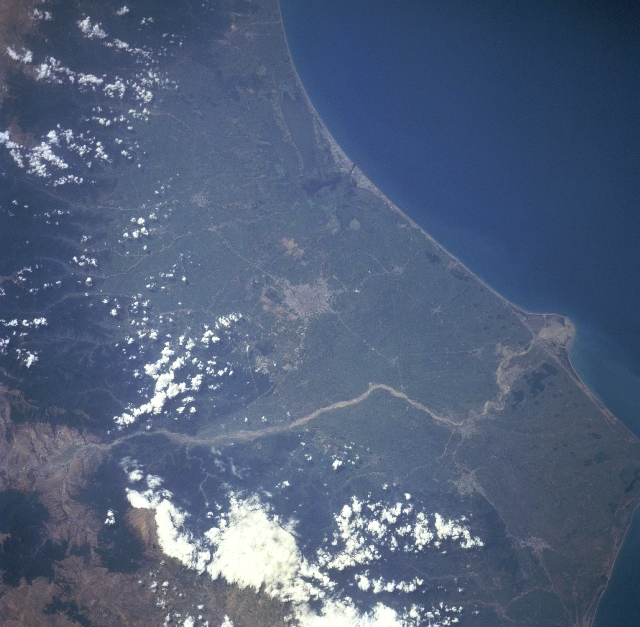 |
| STS091-719-053 Safid River/Delta, Iran June 1998 The Safid River has created a sizeable, swampy delta (upper left corner) along the southwest coast of the Caspian Sea in northwest Iran. Notice the "new" delta (middle left) actively being created by the sediment that is being deposited at the mouth of the Safid River. The Safid River originates in the Elburz Mountains, a small section of which is visible in the upper right corner of the image. This river is the only one to cross the entire width of the Elburz Mountains. The densely forested mountain slopes (dark landscape) are visible along the right edge of the image. Rasht, a major Iranian city noted for its unique cusine and pleasant climate, can be identified (grayish-looking area) slightly below the center of the image. Several other smaller urban areas can also be located on the narrow coastal plain. |
| Images: | All Available Images Low-Resolution 322k |
|
| Mission: | STS091 |
|
| Roll - Frame: | 719 - 53 |
|
| Geographical Name: | IRAN |
|
| Features: | RASHT,COAST,SEND R. DELTA |
|
| Center Lat x Lon: | 37.5N x 49.5E |
|
| Film Exposure: | N | N=Normal exposure, U=Under exposed, O=Over exposed, F=out of Focus |
| Percentage of Cloud Cover-CLDP: | 10 |
|
| Camera:: | HB |
|
| Camera Tilt: | 39 | LO=Low Oblique, HO=High Oblique, NV=Near Vertical |
| Camera Focal Length: | 250 |
|
| Nadir to Photo Center Direction: | NW | The direction from the nadir to the center point, N=North, S=South, E=East, W=West |
| Stereo?: | Y | Y=Yes there is an adjacent picture of the same area, N=No there isn't |
| Orbit Number: | 150 |
|
| Date: | 19980612 | YYYYMMDD |
| Time: | 101339 | GMT HHMMSS |
| Nadir Lat: | 35.8N |
Latitude of suborbital point of spacecraft |
| Nadir Lon: | 51.3E |
Longitude of suborbital point of spacecraft |
| Sun Azimuth: | 247 | Clockwise angle in degrees from north to the sun measured at the nadir point |
| Space Craft Altitude: | 186 | nautical miles |
| Sun Elevation: | 65 | Angle in degrees between the horizon and the sun, measured at the nadir point |
| Land Views: | MOUNTAIN, FOREST |
|
| Water Views: | RIVER, DELTA |
|
| Atmosphere Views: | |
|
| Man Made Views: | |
|
| City Views: | |
|
Photo is not associated with any sequences | ||
| NASA Home Page |
JSC Home Page |
JSC Digital Image Collection |
Earth Science & Remote Sensing |
|
This service is provided by the International Space Station program and the JSC Earth Science & Remote Sensing Unit, ARES Division, Exploration Integration Science Directorate.

|